One of the things I like to do on this blog is mention whenever I find a cool website that has some content about Kauai. And one of the things that I find cool are maps. Being a cartographile (this could be me), I love this elegant map of antipodes (rhymes with serendipities):
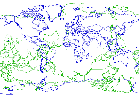
Source: original at Peakbagger.com, I changed the colors and highlighted Kaua’i in red
After all, everywhere is the opposite of somewhere else on this blue marble of ours. You can sort of see that Kaua’i (and Hawaii in general) is one of the few places that is opposite another landmass, and one of the rare parts of the United States that is. You can see more maps like this here, here, here, and an animated globe one here.
So Kaua’i is opposite Africa, somewhere between Namibia and Botswana. While searching for more about the exact antipode of Kaua’i, I stumbled on the Degree Confluence project. Their goal is to document every whole degree intersection of latitude and longitude on the globe; anyone can contribute and many have.
People go out with a GPS, find the “zeros” (where there are whole degrees, with no decimals) take pictures, then report back on the whole adventure. It sounds a bit like geocaching, except you know exactly where to go, and there is no cache—and I confess I have done neither of these hunts. As with many things, it’s the journey that counts, and it’s fun to read people’s random adventures.
The problem is, all the whole degrees of latitude and longitude near Hawaii intersect in the ocean:
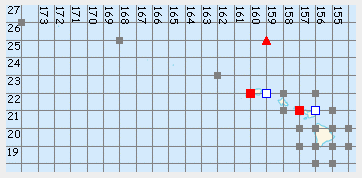
Source: original (and clickable) at confluence.org
But that actually makes for a more challenging adventure, and the two confluence points near Kaua’i have interesting stories attached to them. The first one to the east of Kaua’i at 22N 159W (the white square to the right of Kaua’i on the map above) is 24 miles (38.0 km) due east of Hanama’ulu and is only documented by plane. The other at 22N 160W (red square to the left of Kaua’i) is 14 miles due east of PMRF, the military base on the western tip of Kaua’i, and 3 miles east of Ni’ihau. The confluence hunters chartered a fishing boat, and floated above the spot. They also stopped to climb on Lehua, the little crescent-shaped island north of Ni’ihau and have the only photo I know of on that summit.
And surprisingly, both antipodes of these points have been documented on the website as well. It turns out that both are part of the international border between Namibia and Botswana, right where it runs east-west exactly between these two points. The area appears to be scrub trees and dry grass on either side of the border fences, and I think we can assume it doesn’t look much different in between. What a contrast to Kaua’i.
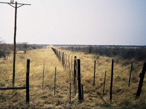 Source: 22S 20E at confluence.org |
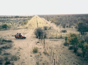 Source: 22S 21E at confluence.org |
So to conclude, everything north of Hanama’ulu is opposite Botswana, and everything south of it is opposite Namibia. In general, you can say that Kaua’i (and most of Hawaii) is opposite the Kalahari desert. Specifically, the antipodesmap.com shows a village called Karakubis in Botswana that is opposite Kapaa, or more exactly the most inland part of Kapa’a at the end of Kawaihau road—I have some friends building a house there, I’ll have to tell them. Wikipedia, which is really starting to amaze me, lists it as Karakobis, in the Ghanzi district of Botswana, population 785 in 2001, so it is not an insignificant town. Google found a local church and the grades of children in the local school in 2005 (!) but no photos; no luck on flickr.com and panoramio.com either.
Here are some more tidbits I picked up while writing this article:
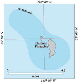 The degree confluence closest to land in Hawaii is far from the accessible islands. It occurs a few dozen feet from shore, right between the emergent rocks of the Gardner Pinnacles, the northernmost (and oldest) of the rocky Hawaiian islands. All of the Northwest Hawaiian islands further away are sandy atolls. These islets are only the size of a football field (what a sad analogy), but the submerged island is larger than Maui Nei (Maui, Molokai, Lanai, and Kahoolawe, which were likely all connected before). What I wonder is whether the confluence might actually be on one of the rocks, given all the inaccuracies in maps and GPS readings.
- Hawaii is not the only part of the US across from land. A tiny bit of Montana and a patch of Colorado are both opposite France, or at least its Terres Australes et Antarctiques Francaises (French Southern and Antarctic Lands). A small piece of Kergulen Island (that I’ve mentioned before) is opposite Montana, and Ile Amsterdam and Ile Saint Paul is opposite a deserted part of Colorado. Kergulen islands is one of my favorite exotic island location, one I would love to visit someday but know the chances are almost nil that I could. Here are some great maps of the continental US antipodes, but the comments conveniently omit the Hawaiian antipodes.
- On the StrangeMaps blog comments, I learned this: One of the more unusual antipodes must be “Maui” Island and its antipode in North Central Botswana, a town with almost the same name “Maun”. The Herero people in Maun actually look somwewhat similar to the Hawaiians. And in both societies, the missionairies clothed the women in “mumus”! See http://en.wikipedia.org/wiki/Herero.
- The US-Canada border is supposed to be on the 49th parallel, and it sure looks like a straight line. But when compared to actual positions on the GPS, the border is a bit of zig-zag. I’m not sure if that’s an artifact of the GPS accuracy, the GPS data model (WGS 84), or the border surveyors. I bet the border is set where it is, and the points of the data model move around since the earth is not a perfect sphere.
- There are two corners of the Pacific ocean that are antipodal points of each other, meaning the Pacific ocean stretches halfway around the globe at its largest point.
- The town of Formosa in Argentina is nearly antipodal to Taiwan, formerly known as the island of Formosa. Rather than being intentional, my reading of the Wikipedia articles suggests it was a coincidence, a testament to the extent of the Portuguese and Spanish explorations.
- As if finding regular geographic points on the globe wasn’t enough, there are also people who find the man-made survey marks that have been created over the years. This is called benchmark hunting, and even though this is getting close to train-spotting in terms of compulsiveness, I still like the idea.