First of all, happy leap-day to everyone!
Being somewhat of a purist who could always find his way with maps and careful observation of the terrain, I was at first reluctant to own and use a GPS. But ever since my wife gave it to me one Christmas, I’ve become an amateur cartographer. I carry it on most of my hikes and keep it turned on. I hardly ever need it to find my way (knock on wood), but I do check it now and then to see the time and distance covered. When I get home, I download the tracks to my computer and transfer them to Google Earth so I can put them in perspective.

The model I have is a Garmin GPSmap 60CS, pictured above on the boardwalk through the Alakai swamp. I made the photo a bit larger than usual so that the unit is exactly life-size on my screen.
I have owned it for at least 4 years now, and it is at least two generations old. I think it cost around $450 new, plus $100 for the digital topo maps that cover the entire US. Newer models such as the GPSmap 60CSx are still in the same price range, but they have improved reception that almost never loses satellites under tree cover. And the latest generation that just came out has satellite imagery instead of vector-based maps. You can read all about the latest models (and their recalls) on a site I found called GPS Tracklog, but I want to sing the praises of my sturdy old GPS.
GPS-wise, the unit has performed as expected. It takes a minute or two to find your location when you turn it one, more if you don’t have a clear view of the sky. That feels a bit long, but that’s normal for hand-held GPS, at least when this model came out. I chose the model with the protruding antenna because it gets better reception than the sleeker models with an internal one. Sure enough, my model works in the forest, and only under very dense canopy or in a deep canyon does it lose the satellite signal. It works inside the car fairly well, but you can’t put it in your pack, so when I’m hiking I clip mine to my shoulder strap with a cell-phone case.
Even in sunlight, the screen is easy to see, the LCD is bright, the graphics are clear, and there is a backlight for use in the dark. The controls work well, I find it easy and staightforward to use, no annoying quirk that erases my data or anything. It gets about 30 hours of running time from 2 AA alkaline batteries, about 20 from the rechargeables I use. My only pet peeve is that with a screen-blanking function, that time could easily have been extended. Functionality-wise, it is a higher-end model and has all the bells and whistles:
- It holds hours of tracks and hundreds of waypoints, all useful for making my maps. After overnight hikes, I do have to save the active track because the track log does fill up. But you still see on the screen everywhere you’ve been until you download the data and erase it from the unit. I can also upload old tracks from my computer and follow them again.
- It gives you average speed, moving speed, distance, moving time, total time, and many more, even the time of day. I sometimes use it just to go jogging, so I can see how fast I’m running.
- It computes altitude with an internal barometer and from the GPS signal, and graphs the measurement over time or distance.
- It computes the sunrise and sunset times for the current location, as well as phases of the moon and its location in the sky. This can be really handy if you’re late on a hike, so you can know when it gets dark and whether you’ll have any moonlight.
- There is a digital compass, but I never use it. When you turn it on, not only does it tell you your bearing, but it also shows the map with north up, no matter which way you turn the screen.
- There are also geocaching features but I never use them. Since geocaching has gotten more popular over time, I would assume that all newer units have this too.
- It also has some route-finding capabilities and turn-by-turn directions so you can use it like the dash-mounted GPS in your car. I’ve never used this either, so I don’t know how good it is.
The unit comes with base maps for the whole US, but that only includes major roads and landforms. In order to be useful for hiking, you need to buy the topo maps that Garmin sells for the unit (you can use the viewer at that link to see the maps). Unfortunately these are only 1:100,000 scale, so there is nowhere near the detail of the USGS maps. Usually, you can still see most topographic features, but you do have to be careful if you’re in a small gully because it may not show up. That’s when you should be relying on your sense of direction anyhow, and since we don’t have white-out conditions on Kauai, that’s usually feasible.
I think the maps are the weakest part of the GPS, not just mine but any brand. I asked Garmin if they will have higher resolution maps, and they said the USGS has only published 1:24,000 scale vector maps for select areas, such as some National Parks. It looks like Garmin does have updated maps called Topo US 2008. They’re still 1:100,000 scale but seem to add a degree of hill-shading to help see the terrain, although it again doesn’t help when you need help finding the right ridge. That website shows there is no coverage of Kauai and the Big Island on those maps, although the viewer they provided did let me zoom in all the way to the highest resolution on Kauai. I’m waiting to see how the raster-based units work (and how much they cost), because with those you can theortically upload the 1:24,000 USGS topo maps from software such as National Geographic’s TOPO! series.
In terms of pure ruggedness, this model is really worth it. Of course, you can’t know that until you take it out and use it, but this one has been good to me, eventhough I’ve mistreated it a bit. You can see a scratch on the screen above, and some covering has rubbed off the buttons, but it hasn’t affected the waterproofness. I once dropped the unit in Wai’alae stream deep in Waimea canyon and thought I lost it. It slipped out of the case, and bounced off a rock just above a small cascade. I searched around under water, above and below the cascade, and found it about 10 minutes later laying on the stream-bed about 15 feet downstream
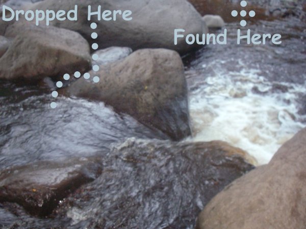
It was still on and functioning when I pulled it out, but it had lost reception under 2 feet of water. Ever since then, I added a wrist strap from a camera to tie the unit to my backpack. Before the dip in the stream, it once slipped out of it’s case while I was trimming some guava trees along a trail, and I hit it with the machete. It has a scar on the back, but again I’m fortunate it stayed waterproof. However, the time I forgot it on top of the car, it flew off at 40mph and tore the rubber casing when it hit the pavement. I assume it’s no longer waterproof, but after that, I was happy it worked at all.