There has been some discussion in the press and on this blog recently about the condition of the Kalalau trail. An article in the Garden Island newspaper paints a scary picture, one letter to the editor concurred and another admitted to cancelling a hike due to that information. While I personally know most of the people quoted in the article, I think they are over-reacting, perhaps in order get the state department of Land and Natural Resources to take action.
I disagree with this approach, and I’m writing this article to inform people so they can be better prepared. There is no doubt that the trail is not maintained regularly. There are many sections where hikers must pay attention and a few that require caution. But except in the case of vertigo (fear of heights or exposure) mentioned in a comment, the trail is passable. At least two other comments agree with me.
So when I hiked the Kalalau trail back in May, I took photos of the difficult sections to post here. I haven’t heard that the trail has deteriorated significantly or been repaired either since then, so I would assume it’s about the same.
Note: Please do not rely too much on this information. Trail conditions can change at any time. My experiences and opinions will necessarily differ from yours.
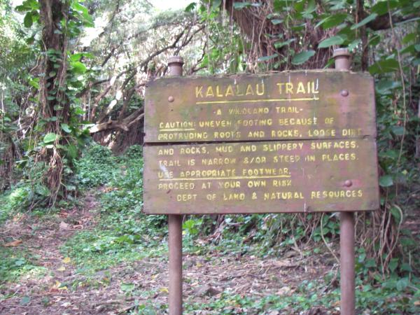
First of all, here is what the owners have to say about their trail:
|
||
|
||
|
||
|
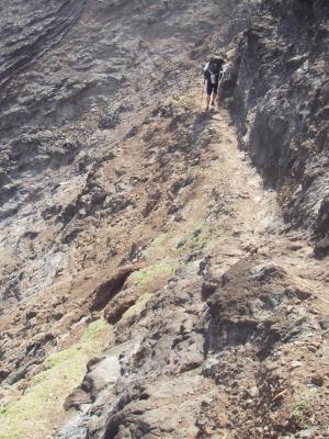
Speaking of scary sections, they are next, as soon as you climb up and out of Hanakoa valley. Here is a photo looking down on some dicey switchbacks, an eroded section and the narrow ledge.
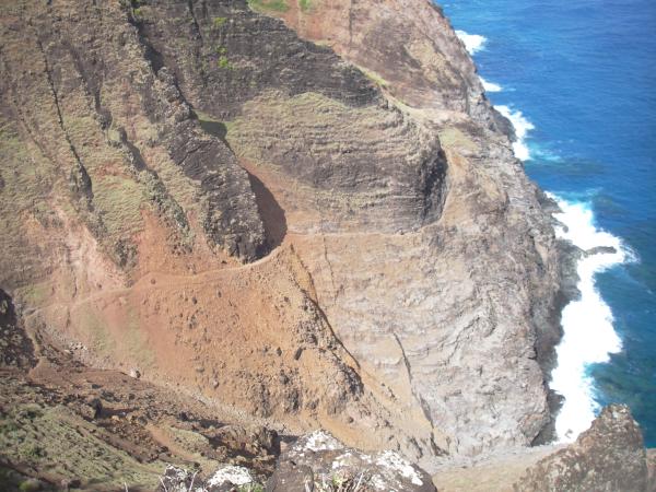
The switchbacks are in the lower-left of the image above. This is a small, steep gully, and what little dirt has accumulated is slowly eroding. Please walk carefully on the last switchbacks and across the gully, the dirt and rocks can be loose, and hikers are the main cause of the trail erosion here. The the slope is not a danger if you fall, but you don’t want to knock rocks onto other hikers below nor destroy the trail. Next are the two most impressive passages:
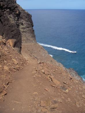
First is a short traverse on a packed dirt and rock ledge. The slope below the ledge is significant and consists of loose rock, so falling off the ledge might be fatal. However, the ledge is sturdy and the tread is flat exept in one short, easy section that hops over a boulder (see overview picture above). |
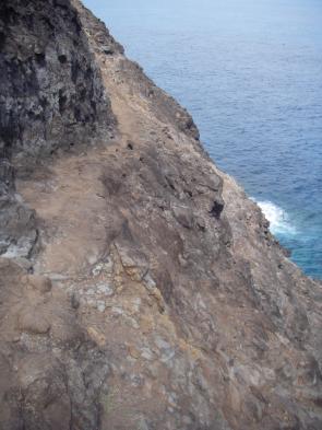
The second is what I call the balcony. The slope below is steep and goes down practically 100 feet (30 meters) to the ocean, so falling off would likely be fatal. However, the ledge is solid rock and the tread is generally flat, though narrower than the dirt section. There are a few steps up and down on this balcony, but nothing that would throw you off balance. |
 |
There are two dangers that you should be aware of. The trail is narrow next to a rock face, so turning around with a large pack, while feasible, could throw you off balance if you bump the wall. Then, I have experienced strong wind right around the corner in the photo above. Again, if you have a large pack, it could throw you off balance in this critical point, or it could blow your hat off.
This photo is looking back at the balcony section, with a backpacker for size. |
| At around 7.5 miles and several small valleys after the balcony above, is a heliport. The landing pad is a grassy ledge to the right of the trail, and there are old terraces, sometimes with makeshift tents, to the left. I consider this an emergency campsite (on the old terraces, not on the helipad). Should you get caught by nightfall here, I would advise against hiking either way, even with flashlights, due to the trail hazards. | 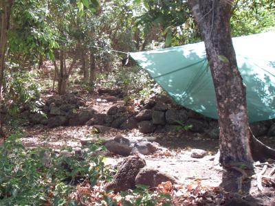 |
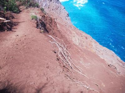 |
Immediately after the stream by the heliport is what I consider the most dangerous part of the trail. Erosion by goats and water here has made the tread of the trail slanted, on gravely dirt, above a steep dirt slope that goes down perhaps 200′ (60m) to the ocean. While it doesn’t look too scary, please pay attention to where you place your feet because one misstep could be very dangerous. |
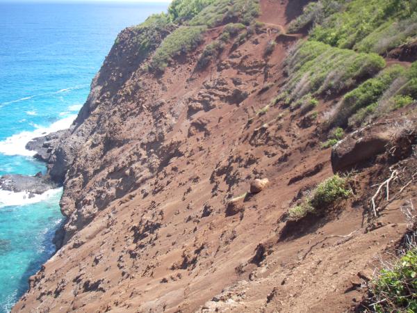
There are several small eroded places for a quarter-mile ( 400m). You can see several of them in the photo above, where the trail curves inward and upward to avoid them. If the dirt is dry, and you step confidently but carefully, you will get by without a problem. If weather conditions are not ideal, you should definitely slow down and step ginergly to get by.
Update: here is a helicopter’s view of this section of trail. The helipad is almost perfectly centered, the part to the right (towards Kalalau) is the eroded part I show above. The part to the left looks similar but for some reason it didn’t have those same problems. And yes, that waterfall does splash directly into the ocean above a sea arch, but you can’t see it from the trail.
After the eroded section, you climb through several small hanging valleys where the bushes grow over the trail and push hikers towards the steep edge, so pay attention to your footing. And just before you reach the top of “Red Hill” where you can finally see into Kalalau Valley, there is another similar eroded section that requires you to step cautiously because of the exposure. The trail on Red Hill itself is eroded and washed out, but there is no exposure to speak of.
|
||
|
I appreciate the detailed hikers’ guide to the trail. I’ve been into Kalalau Valley by boat when I was young, but never tried to hike in and have always wondered about it. It may be a bit too long for me now. Great shots!
Mahalo!
PS – In the old days, my ancestors ranch cattle in Kalalau Valley and took them out via the trail. Imagine that. They said that if a cow got turned around on the switchbacks, all you could do was to push it off.
Your photos are worth a thousand words. When I saw your photo of the partially eroded switchbacks that gave me enough of a lump in my stomach to realize this entire hike is not for me.
I’m an avid hiker, but I’ve only hiked the first two miles in and then back. I was a bit unprepared with water at the time, so it kicked my butt.
Thank you for documenting this trail in such detail.
I read in the following article the trail has been improved by a volunteer:
http://www.kauaiworld.com/articles/2007/07/30/news/news02.txt
I was wondering… is there any cell service on the trail from any carrier?
Phil, I’d heard about the cattle ranching and didn’t believe it, it just seems like so much work for so little pasture. But I read up about it and found some more stories. I’ll post about them sometime soon.
At first I was a bit skeptical about Kristina’s intentions to hike with a cell phone, but she emailed me with more detail: “kind of defeats the purpose of being remote – I know, [but] I am a mother of two, so I would feel better if I knew I could be reached in case of emergency.”
Like it or not, I am fairly certain there is no cell phone coverage on the trail or in the Kalalau Valley. I say it that way because I have always assumed there is none and never carried my cell phone with me. There is no coverage up in Kokee, at the Kalalau valley lookouts, nor are there cell towers on Niihau, the only places in the line of sight. There is a small chance that the military personnel at Makaha Ridge use cell phones, but they probably get their signal from Kekaha or the PMRF near Polihale. I’m no telecom engineer, but I don’t think the signal could reach over or through all the ridges of the Na Pali coast. If anyone is willing to carry a phone and report back here, that would be helpful.
There are emergency communications in Kalalau, but they are very limited. In case of imminent hurricane or prolonged storm damaging the trail, the State Parks will dispatch a helicopter to warn hikers and campers, and possibly evacuate them. That’s one reason a camping permit is necessary, to know how many people need help. I don’t know if tsunami warnings come early enough or if they have a protocol for warning hikers–it’s less likely. If you see the ocean recede, run immediately back to the valley and up the valley trail.
I suppose if someone needs to reach you for a life-threatening family emergency, they should call the State Parks office on Kauai at 808-274-3444. I do not know if they have a policy of contacting campers, but they might be convinced to send out a ranger to notify you. Obviously, they are only open during business hours, I really don’t know what to recommend on nights and weekends. If you are really worried, or have reason to suspect issues, you may want to draft some sort of power-of-attourney statement to be left with someone you trust.
As for communications in the other direction, in case of life-threatening medical emergencies, people have been known to signal sight-seeing helicopters with an SOS written on the beach. In case of other injuries or medical issues, talk to the people around you and see if anyone can hike out for help. Whoever hikes out should have 2 quarters to call the State Parks deparment at 274-3444 for advice, or 911 after hours, I suppose. There is a payphone at Kee Beach park, by the restrooms, and a mile further at Haena Beach Park, by the parking lot. There is no cell phone reception until you can see Hanalei, near the trail to Lumahai beach.
Otherwise, you just have to accept that you are out of touch and out of reach in Kalalau. As a parent myself, I understand Kristina’s concern, but that is just the reality, and for some the appeal, of Kalalau.
They warn by airplane and helicopter for tsunami warnings. Unless the tsunami is locally generated and there is no time. I was just on the Kalalau trail last week during the big tsunami warning after the earthquake in Chile. The planes started flying with sirens early in the AM. The problem is most hikers didn’t know what it meant. Two helicopters landed one at mile 11 and one at mile 8 also. I wasn’t at either mile marker when they landed but most hikers tried to warn others coming the opposite way from the midway point campsite. Although I heard some of the hikers ahead of me did not warn the hikers hiking to Kalalau beach which disappointed me. There seems to be no way to warn the hikers who are in the middle of the trail though other than word of mouth.
I’m headed to the trail next Wednesday/Thursday, and I’m quite excited–though a little nervous. I’m wondering three things:
1.) Should I hike in with 2 Liters or 3 Liters of water? I don’t want the extra weight, but I’m not sure how far apart the water sources are on the trail.
2.) Are the rangers very strict about where you camp? I am asking because I got a permit to camp at Hanakoa, because they were “full” at Kalalau Beach. So, I have to hike about 16 miles the first day, and 6 miles out, rather than 11 a day.
3.) Do I need to bring Deet (insect repellent)? I’d love to save the weight, but not sure about the bugs on the island.
Thanks,
Wes
Hi Wes,
Lucky you to be hiking the Kalalau trail next week. Some answers for you:
1) It totally depends on whether you’re used to hiking with a pack in a humid climate. You do get hot and sweaty, and you’ll want to drink a lot to avoid dehydration. I tend to sweat a lot, but I’ve done it with 2 liters at a time by stopping at every opportunity to drink up AND fill my bottles. Remember you must filter or purify all surface water on Kaua’i.
There are permanent streams at Hanakapi’ai (2 miles), Hanakoa (6 miles), the heliport and the next valley (8 and 8.6 miles), Kalalau Stream (10 miles), and Kalalau Beach (the waterfall at the exact end of the trail: 10.5+ miles). The longest stretch is between Hanakapi’ai and Hanakoa, where there are 2 smaller valleys that sometimes have a trickle, but not reliable and not always inviting.
2) I’m surprised they gave you a permit for a single night in Hanakoa, since that is usually considered a stopover on the way to Kalalau. Did you say explicitly that you’d camp at Hanakoa and then hike out? If the rangers do come, and summer is the time they check most, I believe they are very strict. This means they will tell you to leave, though I’m not sure if they’d fine you the way they do when you don’t have any permit at all (those who just flaunt the system). On the other hand, it sound like you’re going for just one night (sadly), so really, they’d have do a patrol between 4pm when you would arrive and 8pm when it gets dark, and you’d be leaving the next morning anyways.
That said, Kalalau is full so all the good spots will (or should) be taken by permit holders. Please do not set up camp in the waterfall area, but instead in the forested area near the helipad by the rocky beach. Or sleep on the beach near the vegetation line, that should be safe in June. Help alleviate the “overcrowding” by not clearing out a new campsite or trampling the vegetation off the trails.
3) Was that you asking about mosquitoes on tripadvisor.com? Kalalau might have a few mosquitoes up in the valley, but not much at all by the beach. I would save your skin, your back, and the environment and not bother with it.
Have fun.
Awesome pictures thank you so much. I visited Kauai for the first time recently, I think when I go again I’ll do a boat trip to see the Na’Pali Coast, or just walk a short section of the trail as that looks too precarious for me! :-O