The last time I hiked the Kalalau Trail, I took my GPS to record the trail and make a map of it. If you have Google Earth installed, click this link to download the trail data you see here. Also, I just noticed that there are newer, clearer satellite images in Google Earth for parts of Kauai, including Kalalau valley.
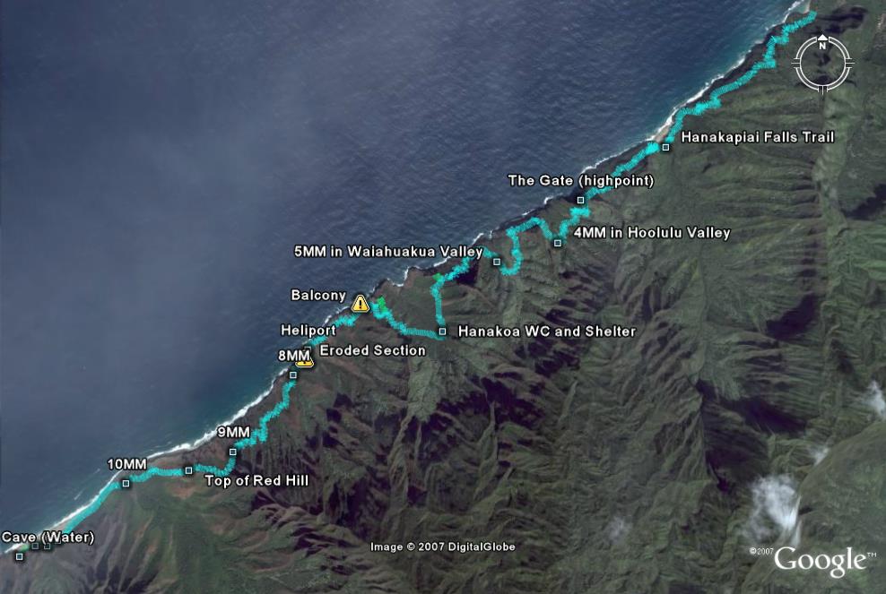
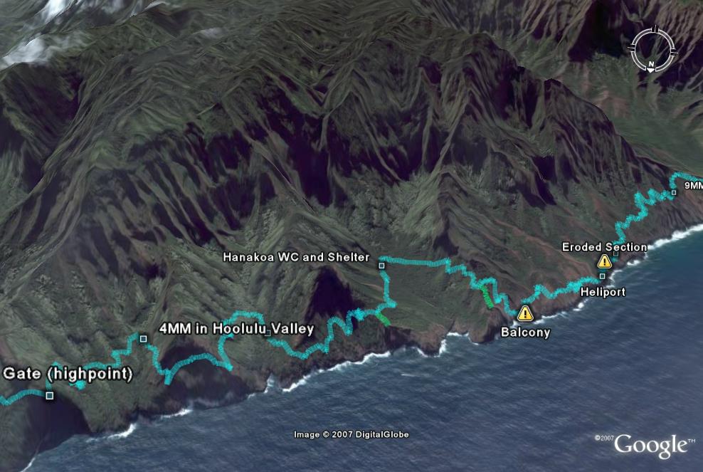
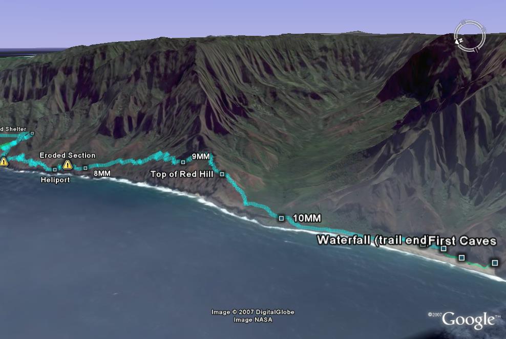
Here are two different and closer views, click to enlarge.
|
||
|
Update: A guy from Oahu wrote to tell me he blogged about his day-hike to Kalalau and back (that link takes a while to load). At the bottom of his page, he made an animated flyover of the trail that he created from my Google Earth data.
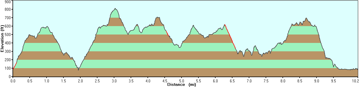
Note: I did have to manually recreate several points in the GPS track because the tree cover was too thick valley walls were too steep in spots for satellite reception. Those points are marked in red on this elevation graph. I also forgot to calibrate the GPS’s altimeter, so all the elevations are 100′ too high, but otherwise generally accurate. Click to see wider graph:
One detail I’m still unsure about is the length of the trail. It is generally described as 11 miles, but the 10-mile-marker is just over a half-mile from the end of the trail. My GPS, which seems to have recorded almost every curve in the trail only measured 10.2 miles. I guess I’ll have to go back and measure it again.
Update March 2011: Google maps keeps evolving and now I can embed the viewer with my Google Earth file right in this article. And now that the Google maps viewer has Google Earth built in, if your browser supports it, you should be able to click Earth to do a “fly over” of this map:
View Larger Map
The link to the Google Earth file returns a file not found error.
The link works now.
Is there any chance you could provide your waypoint file – at least from the start to Hanakapiai? I haven’t done this trail in 31 years and I’m taking my wife to Kauai this spring. The first two miles is all she’s going to be able to handle on this trail. I’m putting everything for our trip on my GPS and would love to have your waypoints if you would be willing to provide them.
Sincerely,
Yar
Just wanted to say – Thank You! Searched the web for a while before I found your excellent site. There is some great information here.
I’m trying to travel light.
Are there enough water sources available to travel with 3L of water and my filteration system for two?
Hi Scott,
Yes, there is enough water along the way, unless you drink more than 1L per mile–I sweat a lot, and even I get by with a 1.5L bottle. The places to find flowing water are Hanakapiai Valley (2miles from trailhead), Hanakoa (4 miles from previous), and almost every mile thereafter. Oddly, the 2 “wet” valleys between Hanakapiai and Hanakoa have little surface water, while every little valley on the “dry” part after Hanakoa has a good stream. Of course, weather patterns can change, but I think unless there is an extended drought, Hanakapiai and Hanakoa will always be flowing.
So the longest stretch without water is always 4 miles, and often much less.
I know you say you do have a “filtration system,” but just to be clear for everyone, filtration is technically not sufficient. Leptospirois is a long bacteria, but only 1 micron in diameter, so theoretically it could go through a 1 micron filter (still the smallest on the market I believe). For this reason, I also add purification drops to my water after filtering, I use the brand SweetWater. Perhaps the new UV or ozone filtration systems don’t need this, I haven’t read their specifications yet.
Here’s a hiking secret of mine: try to hike at a pace where you can breathe through your nose–and avoid talking. Breathing through your mouth loses more moisture and can contribute to dehydration. That’s how that old trick of sucking on a stone reduces your water need.
Great maps. Thank you very much for that information! The Kalalau Trail is truly remarkable and a life-changing experience I will never forget. See you on the trail!
Do you have a filtration system you can recommend and a site I can find it on. Also if you have a place where you typically find te sweetwater drops that would be great! Iam taking myself, my girlfriend, and our two younger siblings on the kalalau trail in July for a planned 4 night stay andmy major concern is how do I provide them with water.
Hi Maveric,
I’ve always used the cheapest 1 micron filter I found on the market. They’ve worked well and I’ve never gotten sick from anything. Here are the links:
You should also be able to purchase these at any outdoor store such as REI. That might be recommended so you can look at the products and even try them out (REI usually has demonstration models sitting out). These two models might be a bit small for 4 people, but then again, you want the lightest filter possible–you’ll just have to spend a bit more time pumping every time to fill up everyone’s bottle.
I don’t know how the UV or ozone purifiers work. They’re usually smaller and lighter, but they probably require batteries, which might be a limiting factor.
I am taking the trail on August 31st and looking for someone to go with. Its my first time on the trail so I would like to have company just for safety sake. If you know of any sites or ways for me to find someone else taking the trail on that day I would really be truely greatful.
thank you for your time,
Eddy
My friend and I are considering to take the hike mid-May this year. Do you have suggestions on books where to get guides on this type of hiking. I have done hiking in the past but not with overnight stays.
Hi Vonn,
The Kalalau trail is very appealing but also very difficult, even for experienced backpackers (backpacking = hiking for several days and carrying everything you need). It can be harder than trails of similar length and elevation gain in the mountains, even without the altitude factor. The main difficulties are: steep sections of trail, muddy areas, narrow trail above cliffs, overgrown trail, rocky and uneven trail, heat and humidity, carrying supplies for 4 days-3 nights minimum (and you’ll wish you could stay longer).
I don’t want to discourage you, but this is not a good trail to learn backpacking. To be safe, I really suggest you do at least 2 moderate overnight hikes near where you live before going to Kaua’i. There is a lot of knowledge you need: planning food, planning your camps, packing your gear, etc. And of course, you need the equipment: large backpack, lightweight tent, sleeping mattress, water filter, etc. Then you can see how well prepared you are for the added difficulties above.
Any bookstore should have a book about backpacking, something where you can learn about equipment and planning. For details about the Kalalau trail, there is On the Na Pali Coast by Kathy Vallier and the NW Kaua’i Recreation Map (it has a lot of text on the back). You can see them in another article (http://great-hikes.com/blog/kalalau-trip-reports/#books) and both are available from Amazon through my “bookstore:” http://great-hikes.com/blog/bookstore
Hello
Me and my girlfriend are going to Kauai To get married from October 24 for 2 weeks. We were wondering what gps to buy because we have never used one before and where wondering if it needs a map up loading because we are buying it in London. we are hopeing to do quite a bit of hikeing and my be go to the secret tunnles. Could you advise me on what you think would be best.
Regards ashley
Hello Andy,
I just want to thank you for the maps you provided, especially the altitude map. we just got back from a two day hike, there and back, and it really saved my sanity on the way there. sooo many valleys and switchbacks.
thanks again,
Gabriel
I have been looking on the Hawaii State camping site and the only sites on the Na Pali you can get permits are is Milolii Valley and Kalalau Valley.
Which one should I spend my first night at?
Is Kalalua the last valley on the hike?
Thanks for your help!
Thank you for your detailed map of the Kalalau trail, Andy! We loved the Trail Profile showing all of the peaks and valleys along the way ! We just got back from 5 memorable days on the beach and did not find the trail a problem. There were narrow and eroded sections, , but with careful foot steps and good tread, no one slipped. The muddiest section was found on the first 2 miles. It was all worth the pristine beauty of the Kalalau Valley!
Stay safe
Hi, Do you know if this map is available for downloading to my Garmin Forerunner 305? I think all I would need is the .gpx
Thanks for the great info, I am planning to hike this in July.
Hi Bill,
You’re welcome. I do have the original file that I created from the GPS points. My Garmin software is old and it crashed while trying to save the GPX, but I do have the GDB file that you should be able to use. I uploaded it here. As I said in the article, some points were re-created after the fact, but most are straight from the GPS. As you can see, it’s an old file. If you make a newer one, please share it as well. You can email it to me: andy at great-hikes.com.
Aloha and happy trails.
We are planning a hike the first in Nov. How much wind will we encounter? Also, how long do you think it will take us to hike then entire 11 miles in one day? We are average backpackers having backpacked Grand Canyon twice. Also, how unnerving is the Balcony?
Do you know if an iPhone 4 GPS with “EveryTrail” map app installed will work? Does the iPhone 4 GPS work even without cellular service? I know that there are GPS apps for the iPhone, just wondering if I could get by with a compass and an iPhone GPS.
Many thanks!
Hi Chuck, I think it will work until the battery dies. The GPS works fine when there is no cell reception, but the problem is that when a cell phone is out of range, it uses a lot of power trying to look for cell towers. And unfortunately, you cannot put the phone in airplane mode to save power, because that disables the GPS as well. So smart phones are great as GPSes for day-hikes, but not for overnight backpacking–unless you have some sort of solar recharger (but I looked into those too and never found a good one).
I know this because I once took my old iPhone 3G on a hike and was disappointed when I figured out why it wouldn’t work. I had the MotionX GPS app, which lets you download maps ahead of time. So you get the maps for the area you will be hiking before you leave home or cell range. You can load up with as many maps as your phone’s memory can hold. I assume the EveryTrail app is similar but I’m not 100% certain. So the limiting factor is the phone itself, not the app. And I don’t think the iPhone 4 has much better battery life. You’d need a phone that you can turn off the cell phone, but keep the GPS on (iPhone configuration lets you turn off Wi-Fi, Bluetooth, even 3G individually, but not the phone service itself). Maybe the Android phones do this, but I haven’t heard. If they could do that, smart phones would be very usable in place of dedicated GPS devices for hiking.
Note that cell reception is very iffy on the road beyond Hanalei. I believe the last cell tower on Kaua’i’s north shore is in Princeville. Hanalei has a strong signal, but then you go around some ridges, and the signal drops. The area around the Hanalei Colony Resort has a line of sight to Princeville and you can make a call. But further towards the end of the road and on the Kalalau trail, there is no cell phone service. There is a pay phone at Ha’ena beach park and Ke’e Beach.
That said, a compass is useless without a good paper map, and neither are really needed on the Kalalau trail (nor the other maintained trails). There is only one way to go, and that is to stay on the trail and follow it wherever it goes.
Thanks, Andy. That makes sense.
I’d like to contribute about the post above regarding the Katadyn Hiker Pro water filter. I contacted them to see if there .3 micon Microfilter could filter leptospirosis bacteria. They said that although the bacteria is typically 1 micron in size, it is because of the shape of this bacteria (long, skinny) that MIGHT let it slip through and because of this they recommended treating the water in addition to filtering it.
Just thought that I would try to contribute to this blog post.
Chuck
I just wanted to circle back and say as a new hiker, I have been introduced to the “Steripen” and if you find clean water that does not need filtering, the Steripen will kill all organisms INCLUDING leptospirosis with ultraviolet light. A liter of water can be sterilized in a couple of minutes.
@Chuck – thanks for the heads up on the Steripen. Used it on my in-and-out to Kalalau and back yesterday. It was a lifesaver as the tradewinds weren’t blowing and no clouds, so hiking from 11-2PM was brutal, particularly as I was on the exposed end of the trail from miles 7-11 (and 11-7) during those hours. Took 4 hrs 40 minutes to Kalalau with no stops other than the occasional breather. 40 minutes at the beach and a difficult 7 hours back (I bonked with about 6 miles to go on the return leg – food wasn’t helping, nor did energy bars/goo). On cooler day, would have been much better.
Drank 300 0z water and it was barely enough. You need to have electolytes when sweating so much, so make sure you add to your water.
The trail is being rehabilitated from miles 4-11 and is in good condition.
There are two kittens hanging out at the prominent rock at mile 4 (just as you pass the wire fence/gate thing). They are very friendly and tame – and hungry. So hungry that they inhaled my energy bars (that had peanuts and not something a well fed cat would ever eat). So, bring a bunch of dry cat food if you read this. Those two could use a good meal. Honestly, if I had the time/energy, I’d hike in with a cat carrier and bring them out. They would make outstanding pets in a good home.
I know this discussion is a few years old, but it is the only thing I could find.
I’m looking for the co-ordinates for the bamboo forest between 2 and 3 miles into the Na Pali/Kalalau Trail.
That rock formation has bothered me since we first saw it back in 2012.
If anyone has images of it, in total…including those huge boulders on each side of that other split in the trail…I’d really love to see ’em.
I really appreciate any energy put towards this…
Cheers,
John
Detroit
Hi John, I don’t recall any bamboo forest along that part of the Kalalau trail. The 2-mile marker is at Hanakapi’ai Beach, and the trail has switchbacks up out of the valley then along the cliff face for the next mile and a half. There are mostly grasses, shrubs, ti plants, and hala (pandanus) trees along that stretch, with an occasional agave. In fact, I don’t recall any bamboo along the coastal trail until you get up into Kalalau valley itself.
The rock you are thinking of is probably the one called “Space Rock” at around 3.5 miles. It is the highest point along the trail, where it must climb up to get over a nearly vertical cliff face below. If you search for “Space Rock Kalalau” on Google or Yahoo, you can find plenty of images and videos.
Hello,
Is a map necessary to hike the Kalalau Trail?
Also, how dangerous the Crawler’s Ledge are around mile 7? Any advice?
Hiking the trail later this summer. Hear report of a few people getting lost on the trail?
Thanks,
Josh
Hi Josh,
No, a map is not necessary to hike the trail. In most places, it’s the only trail around and easy to follow. Even when the trail is a bit overgrown, it’s still easy to follow. There are a few official side trails (one each at Hanakapi’ai, Hanakoa, and Kalalau valleys), but they have signs at the intersections. You will sometimes see hunter trails or pig trails off the main trail, but it’s clear where the real trail goes.
That said, I did see some hikers go off-trail last time I hiked it, so I guess it happens. They were returning from Kalalau and missed a turn in a forested valley (near the 9-mile mark) and went up the other side of the valley instead of following the trail down the valley. In that case, I think the pigs had been rooting around the valley, which made the trail harder to see. Just remember that if you don’t see the trail after a minute, turn around and go back because it’s never that hard to see.
I made these maps for my own enjoyment, and to help people plan their own hikes. I like to play with the GPS and the mapping software to create a record of where I hiked. It’s nice to know what to expect and how much elevation gain and loss you have to deal with. Also, it’s fun to play with Google maps and Google Earth, even if it looks like they broke the embedded KML again.
But if you would like a good map of the area, I recommend the Northwest Kaua’i Recreation map. See my review here. Also, the entire hike is covered on the USGS 1:24000 Haena Quadrangle, which you can probably buy or print online.
I get so many questions about THE LEDGE. Frankly, I have stopped calling it crawler’s ledge and just call it the ledge because 1) the name is freaking people out, and 2) you don’t have to crawl. It is a narrow part of the trail, and yes it is above a steep (not vertical) slope down to the water. But the most impressive part (narrowest above steepest slope) is on solid rock with excellent footing, so unless you suffer from actual vertigo (real fear of heights), it is doable. You should of course step carefully and be aware not to bump into the rock wall if you have a large pack, so you don’t get off balance. You should also be ready in case there are gusts of wind, but otherwise it is not difficult. There are places right before and a mile after where the trail is on an eroded dirt slope, which is actually more dangerous. But again, being aware and stepping carefully will get you through. I should probably write a post with pictures of the ledge so that the info is easier to find. I also took a movie once while hiking through the ledge–not recommended but not that dangerous either.