This is the continuation of the Lonomea Adventure.
With half of everyone’s gear stashed on the other side of the Waimea River, I volunteered to go back and fetch it as soon as the river allowed. I hesitated going the next day because I had no guarantees that the river would be lower, and I didn’t want to hike down and up the Kukui trail just to find out it wasn’t.
Fortunately, the National Weather Service has some very useful information on the internet, including real-time stream gauges and 3-hourly rain gauges. The cumulated rain records revealed that it indeed did rain heavily at Waialeale and most likely in the Alaka’i swamp while we were hiking under a blue sky. The following map shows that the National Weather Service recorded 3.84 inches (9.8 cm) from 8am to 8pm on the day of the hike:
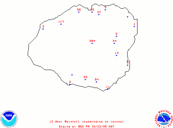
Source: National Weather Service
Honolulu Forecast Office
Even more dramatic is how the stream flow responded to this downpour. The following graph shows the flow of Waialae stream, the next side canyon south of Koaie and very similary in topography. The flow is graphed logrithmically, but since flow is related to the square of the streambed cross-section, I am assuming the logrithmic scale creates a curve that represents actual water depth:
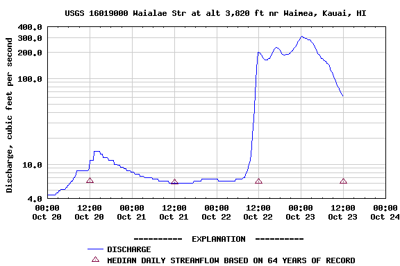
Image credit: U.S. Geological Survey
That graph also shows two other interesting facts. The earlier rains must not have drenched the highlands nor the canyon nearly as much because the stream barely rose in the previous peak. It also confirmed to me that the water was going down and I’d have a good chance of crossing the river, given that it hadn’t started raining again. So I went back the following afternoon and hiked down the Kukui trail, wondering how accurate all these data really were. Fortunately, when I made it to the crossing, it was about halfway down from the high water we saw the day before, enough to get across without getting wet:
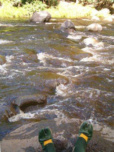
I was able to cross in tabis by stepping on the rocks and not ever getting wet above my knees. Tabis are Japanese water mocassins with non-slip felt soles that I’m wearing in the picture above. I found our hidden bags, crossed again, and hiked out by dusk.
Lessons that I learned from this experience:
- Don’t cross the Waimea river if you know there is rain on the East side of the island. It is most likely raining in the swamp as well, and the streams will rise. There is a great hike up the bottom of the canyon to a water diversion dam that does not require crossing the Waimea River.
- Check the rainfall and stream height before going. Here are the useful links:
- On days when you are not sure of the rain forecast but want go anyways, carry some extra food, an extra shirt or jacket, a water pump, and a lighter. There is a hunter’s camp with sheltered picnic table, fire ring and compost toilet on the other side of the river, right near the crossing.
- Always carry a flashlight on every hike, no matter when you go or plan to get back. I really recommend the Petzl Tikka headlamp because it is small and light.
- Don’t buy tickets for a concert the night of a full-day hike. Even if you get back in time, you might not feel like going.
Jeri Kloss is my very dear friend who related this fantatic story to me after surviving the hike. Thank you for taking care of her and each other, and for helping such a strong, beautiful woman over come her doubts and fears.
Much Mahalo
Vicki Mann