Amateur Geology

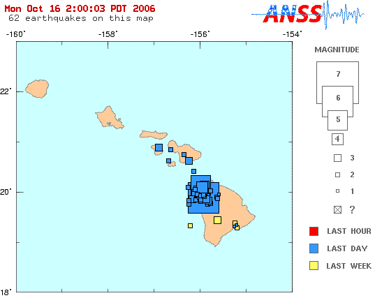
An updated map from USGS shows the large aftershock which didn’t appear as large on the first map. The magnitude of both has been revised upwards, now listed as 6.7 at 7:07am and 6.0 at 7:14am.
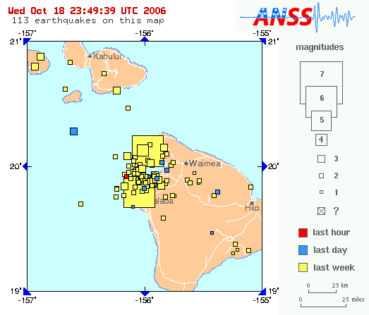


Source (dynamic): http://earthquake.usgs.gov/eqcenter/recenteqsus/Maps/HI2/19.21.-157.-155.php

Both earthquakes were deep (18 and 12 mi–29 and 19 km–below sea level I imagine, so somewhat less below the sea floor), and I’ve heard them attributed to the earth’s crust being strained and crackling beneath the weight of the volcano. That may sound surprising until you realize that Mauna Loa (“Long Mountain”) is more massive than many entire mountain ranges. One study estimates the volume of the island (or maybe just the one volcano–it’s not clear which) to be in the range of “68,750 to 79,343 cubic kilometers, or 16,494 to 19,035 cubic miles.”

And not only does the volcano rise from the sea floor which averages around 18,000′ (very roughly 6000 m) deep, its weight depresses the sea floor even deeper at the center of the island (just like you sink into a water bed). So the same study estimates the tip-to-tip height of Mauna Loa at 10.56 miles (17km), significantly more than the 6 miles (10km) usually measured from the sea floor.
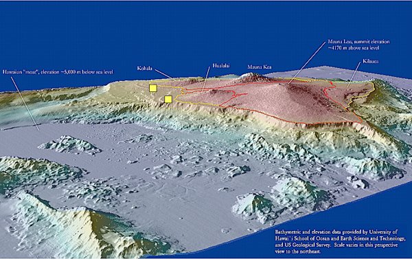


Source: http://oregonstate.edu/dept/ncs/photos/mauna.jpg

This whole explanation of the mass of the volcano is a sort of tangent, but it all makes sense if you look at where the earthquakes happened on the graphic above, as indicated by the yellow squares I added (those are the epicenters, I imagine the hypocenters were located on the downward sloping curve of the crust under the volcano mass). The earthquakes occurred below an underwater extension of the island, furthest away from the hotspot now at Kilauea volcano and in the direction that the plate is moving and forming the Hawaiian chain. If you imagine all the plate tectonics and volcanism as an interaction of fluids with differing surface tensions, this is the point where the “fountain” of volcanic rock is falling back towards the crust. So it is here that the mass of the volcano is most unsupported and weighing down on the crust away from the upswelling at the hot spot.

All this is pure speculation on my part, an educated guess if you will. However, in researching and thinking about all these geological processes, it has made me realize that there are two factors which “form” a Hawaiian island after it moves off the hot spot. The first that everybody knows about is the erosion of the atmosphere and of the ocean on the volcano’s pile of rock. The second is the interaction of the volcano’s mass with the crust beneath it and with itself, causing the volcano to subside and flatten out. This second one is often beyond our imagination because it deals with dimensions and time scales beyond our usual perception.

One reason I am fascinated with all this amateur geology is that I’d love to have an idea of what the proto-Kauai looked like when it was the “big island” of the chain. One hypothesis is that all islands looked similar to the current Big Island when they were over the hot spot. I rather suspect that the interaction of the hotspot and the crust movement and the ocean is akin to the weather: some days you get a lot of rain others not much. That would mean some islands had more mass to start with than others and maybe took longer to erode.

I suspect Kauai was one of the larger ones, because it survives larger and more monolithic than Oahu (one mountain mass versus Oahu’s two main ridges) despite being older. Another clue is the fact that “beyond” Kauai, all the islands are tiny. There is nothing intermediate unless you consider Niihau, but it may have been part of the proto-Kauai just as Lanai and Molokai were likely part of the proto-Maui. So my theory is that Kauai “hogged” the hotspot for a long time, building up a massive volcano, perhaps larger than the current Big Island. We all have dreams of gradeur.

Earthquake!

We were woken up this morning by the earthquatke centered just off the Big Island’s NW Kohala coast. The house shook gently for maybe 10 seconds, the wall hangings banged, one cupboard swung open, but nothing fell or broke. As I was waking up, I thought it was maybe a strong wind buffeting the house but then I realized there was no wind sound. There were actually two earthquakes, we felt the first at 7:11am the second weaker at 7:23am. Those times are approximate, but they are definitely delayed from the “official” times (which I don’t have offhand). We are located 260 miles (415 km) from the epicenter.


Source: http://earthquake.usgs.gov/eqcenter/recenteqsus/Maps/special/Hawaii.php

After the first one, we got up, figured there was no danger and went back to bed—since we sleep in on Sundays. I wasn’t quite asleep when I felt what I thought was a tiny aftershock: just a jitter and the neighbor dogs barked once. I told my wife there was an aftershock, and a few seconds later the house shook a little bit for about 5 seconds, much less than the first time. We didn’t feel any of the true aftershocks, and none of them rattled the wall hangings.

Unless there was some strange localized effects, I doubt there was any damage on Kauai. The electricity never went out, so it was a normal day for us. Maybe some rocks fell somewhere, loosened by the recent rains, but we’ll have to wait for tomorrow’s newspaper to find out. All the local TV stations from Oahu were not broadcasting at first due to a complete power outage on all the other islands. CNN and Fox news had around the clock coverage at first, but not much to say until reporters from KITV (channel 4) on Oahu were back on the air.

So far, there are reports of rock slides on the Big Island, some bridges out on Maui isolating the town of Hana, and a 100 year-old chimney falling on Oahu, but no deaths. Lots of food spoiled and dishes were broken on the Big Island, bug significant damage was limited to a hospital building, some big roofs on stores, and a few blocked or cracked roads. There were a lot of dry rock walls (no mortar, just stacked rocks) and retaining walls that collapsed, damaging some houses and cars. KITV has more of the story and lots of photos on their website.

We’re not really worried about earthquakes here on Kauai, we know they happen at least every decade on the Big Island because of the volcanism, but like today’s they are not felt stronly here. I think they have tiny quakes on Kauai probably due to the island settling, but I think we have nothing to worry about. Of course, a tsunami is always a threat, but we bought our house uphill about 150? (50 m) and a mile (1.6 km) from the ocean, on purpose.

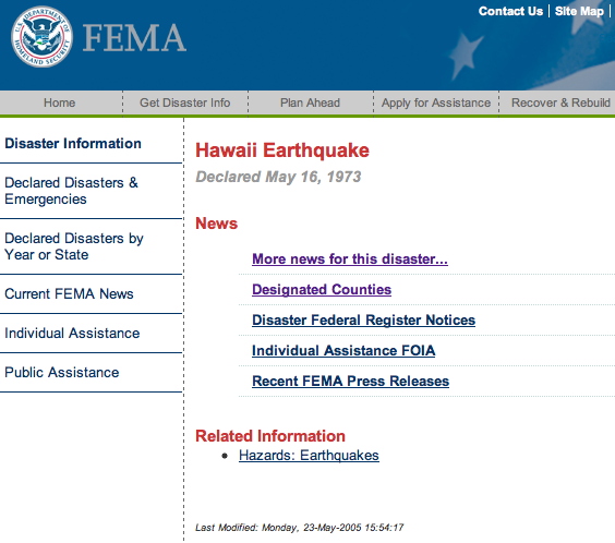
Just as an aside, I wonder how long it will take FEMA to update their website:


Source: fema.gov, 14 hours after today’s earthquake

Solar Hot Water

We finally had a solar hot water system installed in July, and I’m finally getting around to writing about it.

Solar hot water is just a no-brainer in Hawaii. Electricity and propane cost 2-3 times as much as the mainland, and we probably receive 2-3 times as much solar radiation (I don’t have the exact figures) for free. New systems cost $5-7,000, and used equipment such as ours was only $3,000, but there is a 35% State income tax credit, and 30% Federal tax credit, so the system pays for itself in less than 2 years. After that it’s free hot water for 15-20 years.

We had an old 40 gallon (150 liter) gas water heater that worked, but it wasn’t vented properly, so we knew since we bought the house two years ago that we wanted to replace it with a solar system. One of the installers on the island was selling second-hand systems that he removed from an army base on Oahu (many of the units needed maintenance on one part, so they replaced them all—I won’t criticize the army this time because taxpayer loss is my gain). So we now have a 120 gallon (600 liter) tank with three panels measuring 3’x8′ (0.9×2.4 m) each, or 72 sqf. (6.7 m^2) in all.


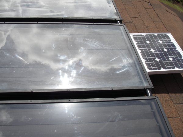
In the first picture you can see a photovoltaic panel above the hot water panels. It generates electricity to run the pump that circulates water from the tank up to the panels. I really wanted this option because it avoids having temperature sensors and a microcontroller running an AC pump. The DC pump runs for free when there is enough sunlight and therefore heat, plus it will keep the panels from boiling over during a daytime power outage. The one problem is that I suspect the PV output current is not quite calibrated, so it circulates water too early before the panels are hotter than the water remaining in tank. Maybe I can fix that with some resistors (anyone with electrical knowledge please feel free to leave a comment with the right way of fixing it).

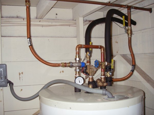
In the second picture, cold water arrives through the copper pipe on the right. The pump is behind, and hot water returns from the roof in the other insulated pipe. Hot water goes to the house through the thermometer and out the copper pipe on the left. The other option I wanted is a thermostatic mixing valve that you see above the thermometer. It mixes cold water with the output of the tank to keep the water from scalding. The gray conduit is the electricity for the backup heater element.

So how well does it heat water? Well, we’ve never had to turn on the electrical backup heater, but there’s only been one day without sunshine so far this summer. In July and August, the tank would heat up to 130-140F (55-60C) and cool down to about 100F (38C) after usage and heat loss by morning. Now in September, the tank is actually getting over 150F (66C) each day because the sun is closer to the angle of the roof where the panels are (the summer sun would be more intense, but it strikes at an angle from the north). That’s another nice self-regulating feature of the system that keeps it from over heating.

Powerful Message

Our friend Gabriel Talyor recently had a strong and beautiful letter to the editor waiting to be published by the Garden Island newspaper. It has been circulating around the island already on various email lists.

A slender young woman placed a sprouted coconut on the table, sat down in front of the microphone, introduced herself, and greeted the commissioners in Hawaiian. It was 8 pm in the cold, harshly lit county meeting room where the planning commissioners sat listening to public testimony. Combined, the two proposed resort/condo projects would total 547 multi-family units/hotel rooms and 964 parking stalls. And they would be located on the beach in the historic Waipouli coconut grove, the heart of Kaua‘i’s traffic hell.

The dozen of us that came to testify against the proposed beachfront resorts had been sitting on hard chairs for nearly seven hours. The morning’s agenda dragged on into the afternoon, but I dared not go out for more than bathroom break, because it could suddenly shift to the public hearings and all could be lost. I was stiff and hungry and I wanted to go home. But then something changed.

The young dark-haired woman spoke in a poetic form that is difficult to capture, but essentially, in a gentle way, she told riveting stories of how our life style on Kaua‘i is being transformed by the unleashed and insensitive growth of tourism. She took us on a journey into the heart of the Hawaiian people and its assault on their traditions. And she led us down a path into the soul of the ‘aina, our beautiful island whose shores are being gambled away in a crap game, and sold out to the highest bidder. When she finished, it was apparent that the atmosphere of the sterile room had risen to a higher level.

While I experienced a feeling of deep sadness, it was not one of despair. Rather, I gained a sense of strength and renewed hope. Hope to believe that we who are concerned about our quality of life and of that of the ‘aina, can successfully communicate with not only the County Planning Commission, but with all the powers that influence growth on Kaua‘i. In addition to presenting my own testimony, I knew that I had to do something more. And it was urgent. I knew that I had to communicate with my fellow Kauaians right away.

So here I am to tell you that if you are horrified by the vision of 1,000 more cars pouring onto Kuhio Highway, if you are worried about the stress of these proposed resorts on other infrastructure: water, sewage, solid waste, and if the thought of an additional 1,200 to 1,700 tourists filling up our parks, beaches, and hiking trails, causes you to clench your teeth, you can do something now.

You can testify about this proposed project without breaking your ‘okole on a hard chair for seven hours. You can write your thoughts, concerns, exasperation and frustration to the County Planning Commission today. They will be accepting written testimony (signed with your address) about this proposed project through the mail or fax up through Monday, August 28.

To: Kaua‘i County Planning Commission
Re: Testimony -Coconut Beach Development & Coconut Plantation Holdings
Send testimony by Fax: 241-6699 or mail to: 4444 Rice Street Lihue, Hi. 96766

It’s going to take all of us to work together to stop this train wreck of overdevelopment and to support reasonable growth on our beloved island. It is not enough to just grumble to our friends. Let’s step into our power and make our voices heard where it counts.

Costco is Ugly

It’s always surprising when construction goes so fast that you find familiar places changed nearly overnight. We shop at Kukui Grove Mall at least every other week, so last time I was shocked to find the view of the mountains now blocked by the Costco under construction.


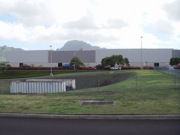
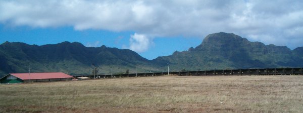
The ugly containers in the foreground belong to Kmart, but at least they are below grade and never blocked the views. The new construction is a huge eyesore that ruins the landscape, I see why they’re called big box stores. From approximately 100 yards away, it still blocks the view 1500 feet (450 meters) up the mountains. The peak is Ha’upu at 2297′ (700m), and it looks truncated there, floating above a big ugly box instead of sitting on its beautiful lush slopes.

I know the area is all retail-oriented, with Kmart, Sears, Macy’s, Kukui Grove, and the Home Depot nearby, but there was still this beautiful viewplane left:


The whole manner in which Costco “invited” itself to the island really stinks. Many people here want more shopping, cheaper prices, and wider selection, and along with tourists who know the store from the mainland, they figured they would be welcomed. However, a majority of people opposed them in the newspapers and popular opinion, and it was clear they are not wanted. So after fighting for their permits, they announced they would not build here because the cost of construction was too high. However, I think that was a ploy to make the opposition back down, because they broke ground 2 months later without telling anyone.

Costco’s partner-in-crime is Grove Farm, the corporation run by Steve Case that owns most of the land between Lihue and Koloa on the other side of Ha’upu. They have turned their agricultural land into development such as Kukui Grove, Puakea golf course, and the nearby Home Depot, guaranteeing them steady revenue until the island is all paved over. I’m not sure whether they sold or lease to Costco, but they are also developing a housing development in the background, behind the 12′ (4m) black fence.

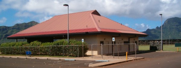
Adding insult to injury, Grove Farm tore down this park and pavilion that used to be located exactly where the box now stands the first photo. It was somehow owned by Grove Farm and far from any neighborhoods but still used by the community for small events and swap meets. It was probably built because Grove Farm at one time was required to provide community space in exchange for turning agricultural land into commercial space, but now it’s gone.