Wednesday, Feb 23rd, 2005 by
Andy |
7 Comments
Filed under:
Activism,
Environment,
Maps
OK, here we go. This is the issue, or rather the incident that made me want to start blogging about Kaua`i.
Back in December, I saw a government notice in the newspaper about some company applying for permits
to build a hydroelectric plant on Kaua`i. Alternative, renewable energy is good, especially for an island that
runs its generators on ever more expensive imported oil. It would be ideal to use the energy we have, and falling water is usually abundant here.
Fortunately, such proposals are available for public scrutiny, and I went searching for the documents online
at the Federal Energy Regulatory Comission (FERC docket P-12534). Buried in one of the PDFs is the following key diagram:
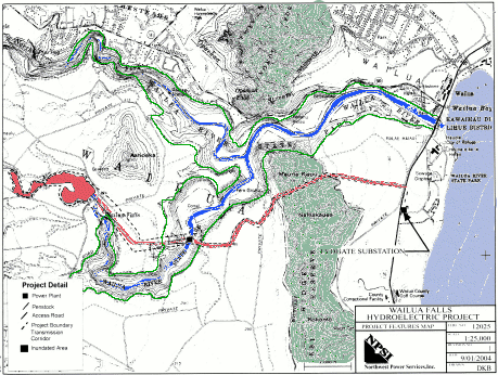
So the proposed dam and reservoir is immediately (about 1000 feet) upstream of the Wailua Falls, just outside the Wailua River State Park. There are plenty of reservoirs on Kaua`i leftover from the days of irrigating sugar cane, so one more isn’t a big deal. Still, you’d think they could use one of the existing ones (I hope to report on the Alexander Reservoir after an upcoming Sierra Club hike). More seriously, the flow over the falls will be greatly reduced, even stopped in times of drought, as is currently done with catchments above 800-foot Waipo`o Falls in Waimea Canyon. And I don’t want to be an alarmist, but any crack or failure in the earth filled dam will silt up the pool below the falls.
The second impact on the public will be the destruction of the South Fork of the Wailua River due to the placement of the powerhouse and it’s access road. The map shows it directly along the river or perhaps on a private land enclave within the State Park. This is an undeveloped area of forest and riparian habitat, lush, green and natural as seen from the lookout on Kuamo`o Road. The natural trace of the river will be interrupted by the powerhouse, and the pristine banks will be cut through by its access road (not shown on the proposal map).
As if that weren’t enough, the power transmission lines and their inevitable access road are mapped straight over a forest reserve on Kalepa Ridge. Again, this is a mostly unspoiled natural feature that is visible to everyone from the major highway between Lihu`e and Kapa`a. Who knows, maybe this will open up Kalepa ridge to hiking, but why can’t we get a trail without a powerline–there’s a novel concept.
I hope I’ve shown that there are major flaws with this hydro-electric project as proposed. Does that mean that hydro-electricity is bad? Not at all, just that this landscape-intensive source needs careful thought and placement. Hopefully, there will be chances for public input, time for redesign, and hopefully relocation of this project. We need hydro-electricity on Kaua`i, but like all the development that’s proposed, we also need to think about where we put it and how we integrate it into our landscape.
I have to add that our bureaucracies seem to be doing their jobs because the Hawaii Department of Health and the US Department of the Interior filed comments notifying the applicant about the environmental regulations that apply.