A Brief History of Kalalau

A reader recently asked me about the Hawaiians who lived in Kalalau valley before and the “hippies” who live there now:

I know Hawaiians previously lived in the valleys, but after it became illegal, they left. Or did they?

I’m not certain about exact dates, but here is a rough timeline. What’s not exactly clear is when and how it became illegal to live in Kalalau.

Historically, Hawaiians lived in certain valleys that could support them (Kalalau was the biggest, but also Honopu, Nualolo, and maybe a few people in others). They created terraces and grew either taro in irrigated plots or dry-land yams, in addition to fishing. Much of the valleys were deforested, and I’m not quite sure what they did for fuel (I never thought of it before, and I’ve never heard anyone speculate on that). I know they had treacherous trails down from the forest in Kokee, so maybe they carried bundles of wood down.

In any case, archaelogists estimate up to 2000 people could live in Kalalau, which I find plausible. I suppose that was before 1800. After the subsistence agricultural society had been displaced by the commodities and merchandise-based economy brought by the missionaries and whalers, farms were abandoned, especially in the hard-to-reach valleys. I think they must’ve still been inhabited in the late 1800’s, as demonstrated by the famous story of Koolau the leper who hid out in Kalalau with other lepers who didn’t want to be sent away.

By the 1900’s, I think the smaller valleys (Nualolo and Honopu) were abandoned. Kalalau was accessible by trail and had more water, so I think people still lived there. The land was sold to one of the big families on the island (not sure of the details, but it may have been the Robinsons), and it became grazing land for cattle. So there must have been a few people running cattle there, probably living seasonally with a few fruit trees and vegetable garden. Incidentally, they used to drive the cattle in and out on the Kalalau trail, sometimes losing one over the edge–and I’m not sure if they also got the cattle in and out by boat–seems like a lot of trouble to me.

I met a local in Kalalau who claims his Aunty was the last person to live in Kalalau, and I suppose that was in the 30’s or 40’s. Sometime after that, it became a state park, and parts of the Kalalau trail became nature reserves (though hunting is still allowed in many areas, so it’s not just tourists on the trail). In the 50’s and 60’s, an African-American doctor retired/gave up his practice and became known as the hermit of Kalalau, in the pre-hippie era. In the 70’s, the hippies were all over Kauai, especially at Taylor camp at Haena, and I’m sure many of them moved to Kalalau when the camp was shut down.

I’m not quite sure of the circumstances, but I suppose 20-50 people lived in Kalalau quasi-permanently over the 70’s. I don’t know if it was tolerated, ignored, or just plain unknown to the park administrators. Nor do I know if they more or less left by themselves or were forced out. I think by the 90’s, there were less permanent residents, probably 10-20, with various free spirits adopting it as home for months at a time before moving on. When I first went in early 2000’s, I think there were less than 10 real residents, with a few people migrating in and out over the seasons. Some of them live by growing weed for sale, as well as collecting welfare, and carrying supplies into the valley.

Does anyone live along the Na Pali? Aside from the legalities, could they?

I do know that over this decade, the park service has totally cracked down on the residents, evicting nearly all, some by force and commando-style. But I get the impression that a small core remain, both hiding up in the furthest reaches, and also grudgingly allowed by the park rangers. They sort of position themselves as care-takers, not trashing the place and keeping out or reporting the inevitable whackos who show up and try to move in. The local guy I met didn’t live there himself, but use to boat in and out regularly to camp, hang out with the residents, resupply them, and carry out trash. I think he was tolerated as well, up to a point.

There was another local of Hawaiian descent who would live there for weeks at a time and claimed to be a caretaker of the spiritual locations in the valleys (old heiau). The park service cracked down on him pretty hard, because he was openly flaunting the permit system and authority of the parks, even though he was doing no harm.

Because Kalalau was historically an agricultural valley, there was one experiment of allowing a caretaker to go in and replant a taro and vegetable patch, sort of as a token gesture to the Hawaiian community. I saw the patch growing once when I was there, but I never saw the people. I don’t think the park continued the experiment, because I’m fairly sure it does not sanction anyone living there now.

So there you have a short overview. Moving into Kalalau is certainly possible, people do it all the time even today, but it tends to be more limited and mostly under fear of being chased by rangers. The rangers come in by helicopter and chase down any “residents” they can catch, so they’re really cracking down, or at least appearing to do so.

A recent comment also asked about the famous library of Kalalau:

I was wondering…I have heard there is a “library” in the valley….a bunch of paperbacks under a tarp….Does it exist and if so… how do you find it. I love to spend time reading…finding a great spot, soak up the beauty and share it with a book but they are HEAVY and if there are books to borrow I would love to do so. What can you tell me?

I believe it was the hermit of Kalalau mentioned above who started the library in the cave he lived in, which I gather was the first sea cave. I imagine that the various people living in the valley after him either kept his books or started new collections. When the rangers raided the valley these past years, I heard they dismantled whole encampments, and that probably included some books. But I don’t know if there was still a big library or whether it survived.

When I was there last year and talked with some of the residents, it sounded like there were still books around, but whether that was the main library or just little collections, I could not tell. What I do know is that it’s not a public library with borrowing privileges. You would need to meet and befriend one of the locals before you would have a chance at receiving any book they might have. And I doubt you would get to see or browse the “library” itself, if it still exists; I think they are much more particular about their hiding places now. However, once you break the ice with them, they tend to be very generous, so who knows what you will find.

Generous or not, it would still be a nice gesture if you brought a book with you and offered it to someone there. Paperbacks aren’t that heavy and are usually small enough to pack on the trail. That might be the best way to open the doors to the library. (Then again, if everyone who reads this and takes a book in, the residents are going to start wondering what the big deal is.)

No Joy From Felicia

What is it with the hurricanes starting with F lately? Two years ago, it was Flossie, and right now Felicia is bearing down on Hawai’i.

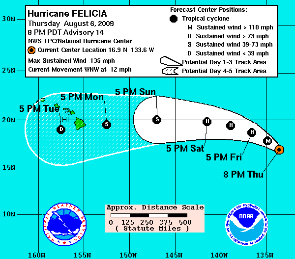
More seriously, this is the first time since I have lived on (and off) Kaua’i that I’ve seen Kaua’i in the predicted path:

NOAAHurricaneFelicia
Source: NOAA/National Weather Service

First the good news: Kaua’i is on the edge of the predicted path, which I interpret to mean less of a chance of being hit. However, storm direction is perhaps the hardest to predict. More encouraging, and hopefully more accurate, the hurricane is predicted to weaken into a tropical depression, with winds under 40 mph (60 km/h), as shown on the graphic above.

The bad news: my family is travelling to Kaua’i without me next week. It looks like they’ll arrive before the storm, and I won’t join them until after it passes. So it looks like they’ll have to put up with lots of rain and avoid camping.

I guess the silver lining is that we’ll be on the island to clean up around our house that we have rented out. The last big storm blew some shingles off, so I might have to go up on the roof to glue them back down.

Update: you can follow Felicia’s progress at the NOAA/NWS Central Pacific Hurricane Center.

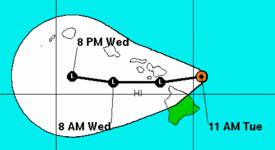
Update for posterity: after targetting Oahu, then Maui, and causing much news reporting, Felicia finally weakened before passing through and making lots of rain but no significant wind on Kaua’i. Here’s the last forecast from the Pacific Hurricane Center, on Tuesday, August 11. They stopped tracking the storm at this point. NOAARemnantFelicia
Source: NOAA/NWS Central Pacific Hurricane Center

The Other LIH

Having a home on Kaua’i but living in California, I’m in the strange position of almost being forced to vacation there. No, I’m not complaining. But it is enlightening to see the island through the eyes of a visitor again, refreshing even. And that includes going through the whole process, and expense, of booking a trip to from San Francisco to Lihue. In searching all the different travel websites, I ran across an interesting tidbit.

When searching for flights, I usually memorize the airport codes of where I want to go, so SFO to LIH. One of the travel websites I use is kayak.com, and it gives me the choice of going to Lihue or Lihir Island, Papua New Guinea (LNV).

KayakLihirIsland
Source: kayak.com

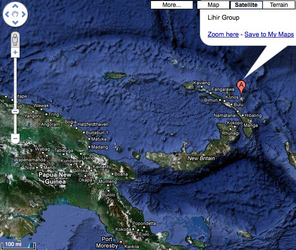
While I admire the global awareness of the algorithm, it seems pointless to offer a location that 99.9999% of the travelers don’t want, and for which they can’t sell me a ticket anyways—SFO to LNV returns no results in the end. But being curious about other islands, I had to see where this was:

GoogleMapsLihirIsland
Source: maps.google.com

And Wikipedia shines through again, with some good information about the place, as well as the local culture. The indigenous name of the island is Niolam, it’s also volcanic in origin, about half the size of Kaua’i, and half as high. Interestingly, it is home to “one of the last remaining cargo cults on earth,” and even if you think you know what a cargo cult is, I encourage you to read that link about them because it gives you one of those rare insights into the human mind.

Lihir Island also produces geothermal energy, so it’s volcano is still active unlike Kaua’i. Also unlike Kaua’i, it has one of the world’s richest gold mines, which I find odd for a volcanic island (but I’m no geologist). More interestingly, the Wikipedia article asserts that all the land still belongs to matriarchal clans. I hope that means they don’t have the development issues and real-estate speculation that we do on Kaua’i.

Even though this was a bit of a chance encouter, the islands seem more similar than not, and maybe could learn something from each other. Kaua’i certainly could strive for more renewable energy, and I’m sure there are a lot of Hawaiian activists who wish the land was still in the hands of Hawaiian families.

Antipodes

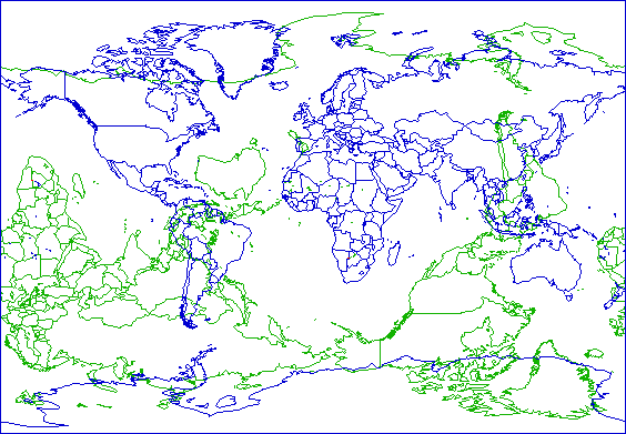
One of the things I like to do on this blog is mention whenever I find a cool website that has some content about Kauai. And one of the things that I find cool are maps. Being a cartographile (this could be me), I love this elegant map of antipodes (rhymes with serendipities):

PeakbaggerAntipodesMap
Source: original at Peakbagger.com, I changed the colors and highlighted Kaua’i in red

After all, everywhere is the opposite of somewhere else on this blue marble of ours. You can sort of see that Kaua’i (and Hawaii in general) is one of the few places that is opposite another landmass, and one of the rare parts of the United States that is. You can see more maps like this here, here, here, and an animated globe one here.

So Kaua’i is opposite Africa, somewhere between Namibia and Botswana. While searching for more about the exact antipode of Kaua’i, I stumbled on the Degree Confluence project. Their goal is to document every whole degree intersection of latitude and longitude on the globe; anyone can contribute and many have.

People go out with a GPS, find the “zeros” (where there are whole degrees, with no decimals) take pictures, then report back on the whole adventure. It sounds a bit like geocaching, except you know exactly where to go, and there is no cache—and I confess I have done neither of these hunts. As with many things, it’s the journey that counts, and it’s fun to read people’s random adventures.

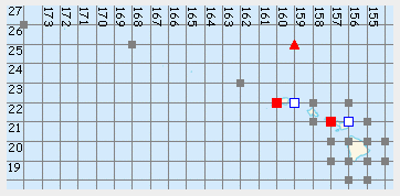
The problem is, all the whole degrees of latitude and longitude near Hawaii intersect in the ocean:

ConfluenceHawaiiMap
Source: original (and clickable) at confluence.org

But that actually makes for a more challenging adventure, and the two confluence points near Kaua’i have interesting stories attached to them. The first one to the east of Kaua’i at 22N 159W (the white square to the right of Kaua’i on the map above) is 24 miles (38.0 km) due east of Hanama’ulu and is only documented by plane. The other at 22N 160W (red square to the left of Kaua’i) is 14 miles due east of PMRF, the military base on the western tip of Kaua’i, and 3 miles east of Ni’ihau. The confluence hunters chartered a fishing boat, and floated above the spot. They also stopped to climb on Lehua, the little crescent-shaped island north of Ni’ihau and have the only photo I know of on that summit.

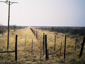
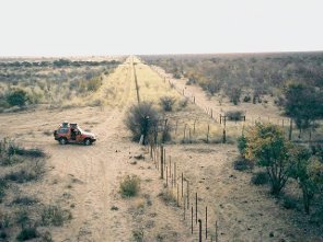
And surprisingly, both antipodes of these points have been documented on the website as well. It turns out that both are part of the international border between Namibia and Botswana, right where it runs east-west exactly between these two points. The area appears to be scrub trees and dry grass on either side of the border fences, and I think we can assume it doesn’t look much different in between. What a contrast to Kaua’i.

Confluence22S20E
Source: 22S 20E at confluence.org
Confluence22S21E
Source: 22S 21E at confluence.org

So to conclude, everything north of Hanama’ulu is opposite Botswana, and everything south of it is opposite Namibia. In general, you can say that Kaua’i (and most of Hawaii) is opposite the Kalahari desert. Specifically, the antipodesmap.com shows a village called Karakubis in Botswana that is opposite Kapaa, or more exactly the most inland part of Kapa’a at the end of Kawaihau road—I have some friends building a house there, I’ll have to tell them. Wikipedia, which is really starting to amaze me, lists it as Karakobis, in the Ghanzi district of Botswana, population 785 in 2001, so it is not an insignificant town. Google found a local church and the grades of children in the local school in 2005 (!) but no photos; no luck on flickr.com and panoramio.com either.

Here are some more tidbits I picked up while writing this article:

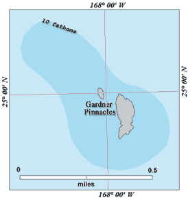
  • NOAAGardnerPinnaclesMapThe degree confluence closest to land in Hawaii is far from the accessible islands. It occurs a few dozen feet from shore, right between the emergent rocks of the Gardner Pinnacles, the northernmost (and oldest) of the rocky Hawaiian islands. All of the Northwest Hawaiian islands further away are sandy atolls. These islets are only the size of a football field (what a sad analogy), but the submerged island is larger than Maui Nei (Maui, Molokai, Lanai, and Kahoolawe, which were likely all connected before). What I wonder is whether the confluence might actually be on one of the rocks, given all the inaccuracies in maps and GPS readings.
  • Hawaii is not the only part of the US across from land. A tiny bit of Montana and a patch of Colorado are both opposite France, or at least its Terres Australes et Antarctiques Francaises (French Southern and Antarctic Lands). A small piece of Kergulen Island (that I’ve mentioned before) is opposite Montana, and Ile Amsterdam and Ile Saint Paul is opposite a deserted part of Colorado. Kergulen islands is one of my favorite exotic island location, one I would love to visit someday but know the chances are almost nil that I could. Here are some great maps of the continental US antipodes, but the comments conveniently omit the Hawaiian antipodes.
  • On the StrangeMaps blog comments, I learned this: One of the more unusual antipodes must be “Maui” Island and its antipode in North Central Botswana, a town with almost the same name “Maun”. The Herero people in Maun actually look somwewhat similar to the Hawaiians. And in both societies, the missionairies clothed the women in “mumus”! See http://en.wikipedia.org/wiki/Herero.
  • The US-Canada border is supposed to be on the 49th parallel, and it sure looks like a straight line. But when compared to actual positions on the GPS, the border is a bit of zig-zag. I’m not sure if that’s an artifact of the GPS accuracy, the GPS data model (WGS 84), or the border surveyors. I bet the border is set where it is, and the points of the data model move around since the earth is not a perfect sphere.
  • There are two corners of the Pacific ocean that are antipodal points of each other, meaning the Pacific ocean stretches halfway around the globe at its largest point.
  • The town of Formosa in Argentina is nearly antipodal to Taiwan, formerly known as the island of Formosa. Rather than being intentional, my reading of the Wikipedia articles suggests it was a coincidence, a testament to the extent of the Portuguese and Spanish explorations.
  • As if finding regular geographic points on the globe wasn’t enough, there are also people who find the man-made survey marks that have been created over the years. This is called benchmark hunting, and even though this is getting close to train-spotting in terms of compulsiveness, I still like the idea.

Happy Father’s Day

Prompted by a story on Hawaii Insider and in honor of Father’s day, here is the image of Hawaii that my father gave me as I was growing up.

My parents visited Hawaii in 1971, the year before I was born. Even though I got to travel a lot as a child (when we lived in France and toured Europe), I was always secretly disappointed that my older brother got to see these far-flung islands. A case of sibling jealousy more than rivalry, it meant that he had travelled significantly further west than I, nevermind that he was just a toddler and didn’t even remember it.

My parents lived near Washington DC at the time, and so it was a big trip for them. I don’t know if this was common at the time, but they spent nearly a month in Hawaii and toured all the islands. Of all the things they saw, here is the story that my Dad always told about Hawaii:

On one of the islands, I’m not sure he told us the name of it or perhaps didn’t even remember it himself, there is a beautiful beach at the end of the road. Behind the beach are towering walls of black volcanic mountains, covered in lush green forest, and full of wild orchids. Dad has always loved flowers of all sort, and what could be more exotic to a native of Ohio than orchids blooming in the wild. He had heard or read that there is another beach over the cliffs, but the only way to get there is a steep trail. So my mother stayed at the end of the road with my infant brother, and my father tackled the trail in search of orchids and the other beach.

After some time on the difficult trail, my dad finally reached the other beach. His story didn’t say whether he saw any orchids, chances are slim right along the trail. But, probably even better, what he saw at the beach were naked women. He called it a nudist beach, but I’m sure they were hippies that he saw there, on their peregrinations between Taylor Camp and Kalalau. He clearly remembers the sea cave to the right of the stream, because that’s where they were hanging out.

Then he learned that the trail continued, up over the ridge to another beach, then another, and another, and every one of them a “nudist beach,” like paradise on earth. But he had to turn around and go back to the beach at the end of the road. I’m not sure what my Mom’s reaction to this story was, or whether he even told her at first, but when he told the story later, he often said he wanted to go back and see all those other beaches.

It would be another 20 years until I saw Honolulu for myself, and another 10 more until I saw Kaua’i, where I hiked the entire Kalalau trail on my first visit. I can’t really say I was following my Dad’s vision, because I was following my girlfriend, now wife, who knew the trail and its inhabitants—and we were part of the naked crowd in Kalalau. A year later, we moved there, my parents came to visit, and my Dad finally got his wish: my Mom dropped us off at Ke’e trailhead, and we hiked the trail together, all the way to Kalalau. And you know what? He was half right. The trail between Hanakapi’ai and Kalalau has absolutely no beach access for 9 miles, but the naked hippie-chicks are still there. Not so much in Hanakapi’ai anymore, but definitely in Kalalau and sometimes along the trail, walking around like Eve in the Garden of Eden.

So Dad, thanks for the stories about far-off places, thanks for sparking my imagination about Kaua’i, and thanks for sharing your love of hiking and beautiful scenery. And now I realize why I’m always driven to see what’s just over the next ridge.

… And no, I wasn’t conceived in Hawaii, as it later occured to me to ask my mother. Which is too bad because not only would it give me a native connection to the islands, it would’ve given me bragging rights over my globe-trotting brother.