On the Kuilau Ridge hike last Sunday, I caught a few glimpses of Mt Waialeale through the clouds. You often hear about how the Hawaiians used to climb up from Wailua once a year to the heiau atop Mt Waialeale, and I realized I was now looking at the possible routes.
Conventional wisdom says they climbed up to the col that the Powerline trail crosses between two points labeled Maheo and Kualapa on the topo map, and then followed that dividing ridge steeply up and over the prominent Pohakupele (Pele’s Rock), a false summit to the upper plateau of Waialeale. This seems plausible, because the Powerline trail demonstrates that it is easy to reach that ridge, and it seems to slope fairly gradually up to the inevitable steepness of Pohakupele.
The rest of the modern story is that this path was last climbed in the 1800’s, once even by a haole (white person), but that a rock slide has since made the treacherous path impassible. Though I’ve heard somebody wonder if the trail was just simply lost to the vegetation. Nevertheless, some people are still intrigued by the idea of climbing to Waialeale from the east side, some are even trying to find that way, and some are also failing and getting rescued.
For those trying to find a way without getting stuck up there (no guarantees), here’s my purely specualtive contribution. Last Sunday, the way the clouds and sun were shining made it apparent that there is a large cleft, 200-300 feet (60-100 m) deep, in the ridge of the assumed path.
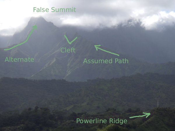
The height and steepness of the cleft are not readily apparent on the topo map (just above the 3000′ contour label), and I hadn’t noticed the cleft at all other times I’ve had good views of that area. Of course, if ancient Hawaiians or a modern adventure-seeker did manage to reach the cleft, they may have the wherewithal to climb over it or around it. But having hiked in similar places on hunters’ trails, I think it is either impossible or suicidal to attempt without any kind of trail. The cleft looks too steep to climb down and back up, and the cliff face too vertical to allow getting off the ridge.
However, the same view offered me a plausible alternative route that I’ve labeled on the photo. A second ridge also leads up to the false summit that is Pohakupele, generally steeper, but smoother and without any large gaps. It is very steep near the top, but the photo shows the other ridge is just as steep in that area. This alternative ridge begins down near the Wailua river, near the beginning of the Tunnel hike, and is much more direct than following the Powerline ridge to the col. Given the fact that the cleft in the assumed ridge is probably too large to be the landslide that supposedly closed the other route, I speculate this steeper ridge is the old Hawaiian route.
Now all I need is for somebody to tell me if this new route can be climbed.
WARNING: climbing off-trail in the wilds of Kauai is a dangerous idea. What looks like a smooth ridge from a distance is a jagged ridge of crumbly rock covered in dense vegetation that you cannot simply push through, but you can easily fall through with fatal consequences. Exercise extreme caution and proceed at your own risk.
Good information. Hope you find the following story of mine interesting and informative.
Hank Soboleski
Kapaa
Scaling Waialeale’s Eastern Face
In ancient Kauai, Mount Waialeale was a most sacred place.
Each year, Hawaiian chiefs and priests would climb Waialeale’s forbidding eastern face to the summit, where they would make offerings of flowers and wreaths to their god Kane at a small, stone heiau called Kaawako.
The Hawaiians began their annual journey near the mouth of the Wailua River. From there, they traveled upstream by canoe, following the northern course of the river until it was no longer navigable.
They would then walk in the shallows until they came to the base of a ridge that would lead them up to a false summit called Pohukapele and then on to the top of Waialeale. Atop this ridge (which today forms part of the boundary separating Kauai’s Hanalei and Kawaihau Districts), the travelers would camp for the night at the 2,300-foot level.
The next day, they would follow the spine of the ridge upwards to the northern end of Waialeale at 3,200 feet.
The climb from there to the summit, another 2,000 feet above them, was steep, slippery, and treacherous. Rope ladders, secured at the summit, were needed to climb the final leg. They would then make their offerings at the Kaawako heiau while chanting praises to Kane.
When the United States Exploring Expedition led by Navy Lieutenant Charles Wilkes visited Kauai in 1840, it learned that Hawaiians still regularly climbed Waialeale’s eastern face to the summit in clear weather to view Oahu about 100 miles away.
Historian James Jackson Jarves also noted likewise during his observations between 1827 and 1842.
In 1870, Grove Farm Plantation owner George N. Wilcox also climbed Waialeale to the summit by following the same trail the Hawaiians had climbed, but when Wilcox climbed it, the trail was overgrown and rarely, if ever, used.
George Wilcox repeated the climb in 1874 with George Dole and Fred Smith.
About 100 years later, Valdemar Knudsen, with Kauai helicopter pilot Jack Harter aloft in radio contact, made a dauntless attempt, but was turned back at 3,000 feet by impassable terrain.
No one has scaled the eastern face of Kauai’s sacred mountain since 1874.
Thanks for the details, Hank. I’ve enjoyed your history columns in the The Garden Isle. Stories of Kauai’s past are not that abundant, making yours so much more valuable.
You confirm the dates and names of people who actually have been there. I’m trying to match your description and elevations with those on the USGS topo map. One discrepancy is that the Hanalei-Kawaihau dividing ridge does not reach the Wailua river, whereas the alternate ridge I describe does. Actually, it would be easier to follow the present day “Tunnels” trail a little ways away from the river and join the alternate ridge on a slightly less steep route.
Both the dividing ridge and my alternate have inflections around 2300 (from uphill to steep) and around 3200 (from steep to extreme), so I cannot differentiate them based on that info. Do you have any place names? Also, I’m puzzled by the 3200′ figure, because Pohakupele and the beginning of the Waialeale plateau beyond are around 4200′.
Anyways, I imagine it’s difficult to have accurate routes and elevations given the oral tradition and lack of maps in the 1800’s.
Hi Andy:
Thanks for the heads up on the elevations in the story that don’t match the map. Will need to recheck my sources.
You may wish to contact Jack Harter. He acted as a spotter for Knudsen when Knudsen made his attempt in the 80s, I believe it was. He’s the man who told me about the need for ladders. Harter may be able to answer some of your questions.
Might be worthwhile to get a chopper to follow the ridge line to the top and film the terrain.
But, I am no climber. Just very curious about how people were able to climb Waialeale. The old Hawaiians maintained a trail to the top.
When you do make an attempt, please let me know.
Mahalo,
Hank
Hi Hank,
I can believe the need for ladders. There are other steep peaks on Kauai where a fixed rope definitely makes the climb possible.
I am not a big fan of helicopter reconaissance, since the Hawaiians did without. Though I suppose it’s not “cheating” any more than topo maps and satellite imagery. Still, I like the idea of being on the ground and depending on one’s own orienteering abilities.
But I am not about to go exploring there, it’s too risky with or without a spotter. Do you know anything about the guy O’Quinn whose rescue story I linked to in the original post above? I know people who would like to go someday and I’ll pass along any information to them.
Hi Andy:
No, first time I’d heard of O’Quinn. Missed that story in TGI.
Re: cheating: The old Hawaiians had generations of time to figure the way to the top and generations to use it. We only have this one and only life of ours to do what they did.
Just off the top of my head, since I know next to nothing of climbing:
The people will need to be in excellent condition and experienced climbers. They’d need to be hard workers, too, since a trail would need to be cut through the vegetation growing on the spine. Stout-heartedness is another qualification, since fearsome drop-offs would greet them on either side of the spine. I imagine moutaineering equipment like ropes and climbing gear would have to be lugged along. A good plan. And, time and patience and a no-quit attitude.
It’s good to hear from you. I’m not alone in wondering about climbing Waialeale — from the eastern side.
Hank
Aloha Andy,
My partner Mike and I have been looking into see if the eastern ridge is possible these days. After recently hiking out the Powerline Trail to the ridge that connects to Poha and trying to follow it west we found that there was no sign of a trail and heavy growth of uluhe and guava.
So, it looks like for now, the only way to the summit is up from the swamp.
Hope the wife and child are doing well!
Patrick
http://www.waialeale.org/text/pohakupele_ridge.html
The website above has some good info about the east ridge approach.
i scanned around a bit, but could not tell – do you know of a website called http://www.waialeale.org? if so, i am not surprised. if NOT – you gotta know! the guys who put it together are “peakers” they go all over the country climbing to the highest point in each county. well, as you know the highest point in THIS county is mighty hard to get to – so they made a whole website about it that iswell worth checking out for folks like you who like to hike around this garden isle.
aloha,
jonathan
gee, what’s that url in th post above mine?
Has there been any update to this information?
Nothing new that I’ve heard of.