I wish we knew what the Hawaiians called this place at the foot of Mount Waialeale and Kawaikini, now called the Blue Hole. That name was invented recently by haoles, but I don’t like it because it’s inaccurate and not lyrical. Nor is it the Waialeale Crater, as another purist points out, because it was not the site of an eruption, though it may be the gorge that has eroded out from under the crater.
To further complicate matters, people are starting to call the terminal cliff a “weeping wall,” which is just too lyrical.
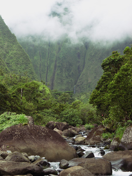
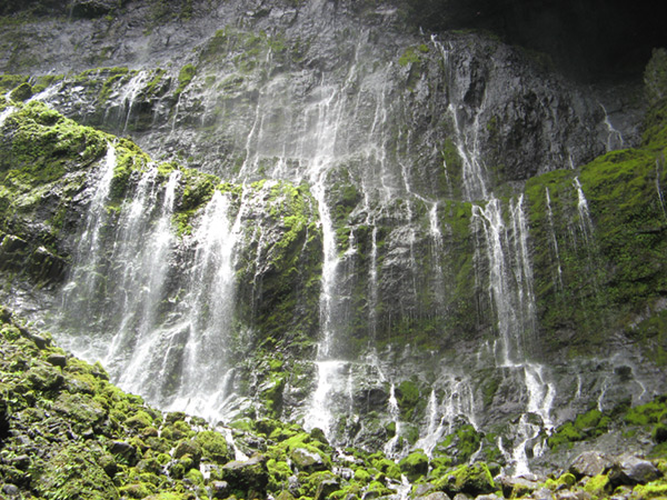
Whatever it’s called, it’s a very unique place where a river springs forth at the bottom of a cliff 3000 feet (roughly 1000 m) straight down from the highest point on the island and carves a deep but short canyon out into the eastern lowlands. It’s also a very difficult hike combining 2 miles of slippery boulder hopping and 1 mile of difficult route finding. But it’s always an incredible trek, and I finally took a camera on this hike to share the experience. But first …
WARNING: crossing rivers, boulder-hopping, and swimming in waterfalls are dangerous activities. Rivers can flood quickly and may sweep you away easily or to trap you on the other side. Waterfalls sometimes carry rocks and branches with fatal consequences and the nearby cliffs are unstable. Hiking where there is no trail is also dangerous due to steep slopes and drop-offs. Exercise caution and proceed at your own risk.
For this hike, you’ll need tabis, felt-soled shoes sold at fishing supply stores. The best kind are the black and gray kind that look like little boots–the green sock-like ones are too flimsy. Other water shoes may work but will all slip to some extent on the wet and slimy rocks.
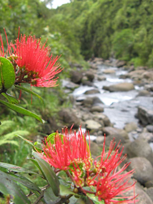
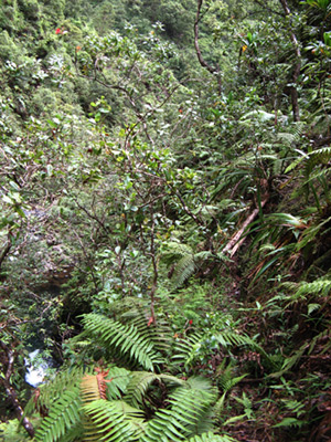
The forest road from the Wailua arboratum ends at the weir at the entrance to the gorge. From there, you just follow the river, alternatively hopping over boulders and walking in the water. Sometimes, there are little side trails in the forest, mostly on the right side as you make your way upstream.
As you progress, you get the feeling you’re entering a very special place, isolated from all the rest of Kauai.
|
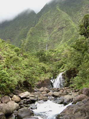
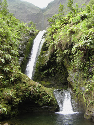
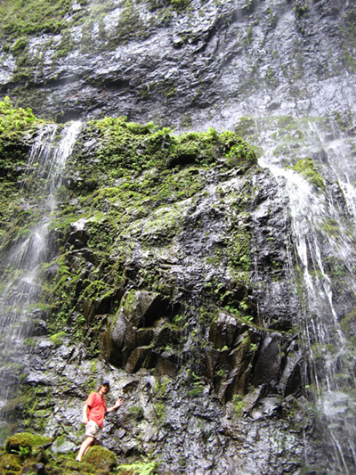
But what a waterfall it is, with two streams falling into the same pool, and a third flowing in from a narrow gorge, off to the left not visible in the picture below. I call this the three-way convergence, but I’d be open to a better name. The right-most waterfall is fed by the falls you can see above it.
|
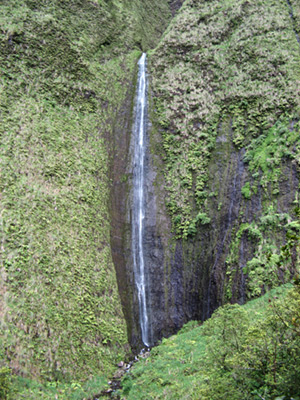
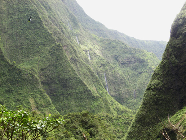
In some places, you get a great view of the inner gorge (above). But mostly, from below, you don’t appreciate the height of the wall over 2000′ high. Looking backwards (below) you can see a 4-tiered waterfall, the one that fed the rightmost falls at the 3-way convergence. This picture also shows one of the helicopters that came in to hover for a few seconds and fly back out.
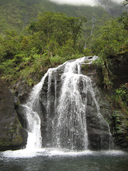
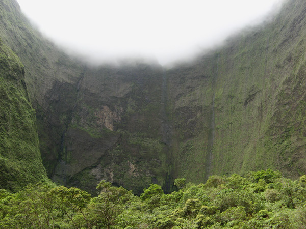
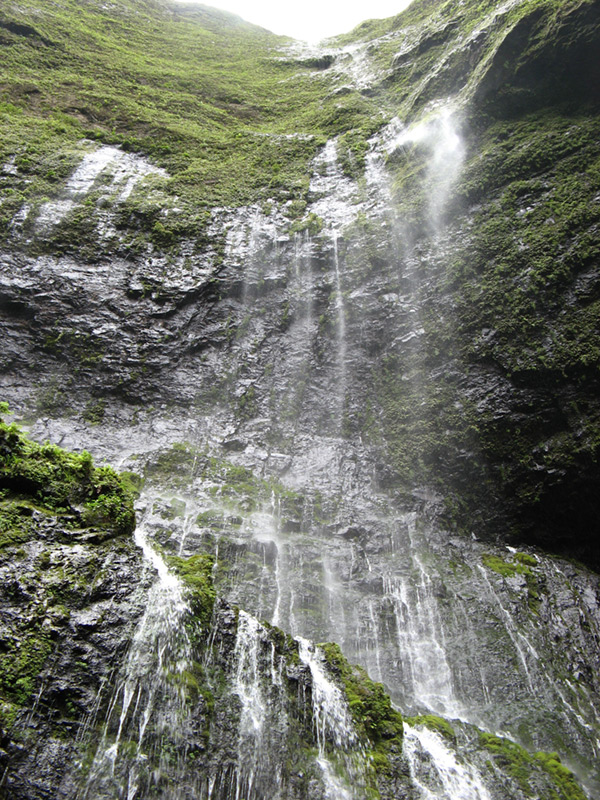
Now you can see the destination of this adventure, the springs at the back wall that are the headwaters of the Wailua river. But you’re not there yet.

As we finally got close, we had a single ray of sunlight shine on the waterfall making it sparkle.
|
Also, you can now see the scale of these falls, which are about 40 feet high and 80 feet wide. Most of the water comes from springs above the nearest ledge, some from springs higher up, and a small trickle from all the way at the top of the mountains. Looking up, you can almost see the top, at least the top of the drainage coming from near the summit.
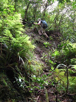
On the hike back, it was not always easy to find the path we had taken. It would’ve been very easy to get lost in places. There are other dangers:
|
After that, it’s a long slog back to the three-way convergence, and another long and tiring boulder hop in the cold river water back to the weir. Be very careful when you’re tired and hopping on slippery rocks. All told, it takes anywhere from 6 to 8 hours depending on how far you go, what shape you’re in, and how long it takes you to find the “trail.”
The fine print: The information and photos in this article are for illustrative purposes. For example, some photos are taken from side trails, so you can’t rely on them to find a route.
Actually, let me restate that warning: This is a very difficult route. There is no trail, and there are no trailblazers that you can rely on. You cannot rely on the existing tracks you might find in the vegetation because apparently many unknowing people have gone the wrong way. And there are some serious drop-offs between the ravines in this gorge, and they can be hidden by vegetation. Never go down a slope that you cannot get back up, you will become trapped further down the waterway. As one commenter says, ALWAYS turn around to be back before dark on this hike, boulder-hopping in the dark is asking for an accident.
Look at those last two photos again. If you’ve never done anything like this before, do not start here, because you will not have fun.
Amazing. I’ve been reading your blog for a while now; you do a great job of portraying your experiences through pictures and words.
Keep writing, I will keep reading.
These pictures are the reason I believe Kauai is the most amazing place on earth. Absolutely beautiful. Keep up the good work!
“All work and no play make John a dull boy”. Make sense isn’t it? Yeah, even though machines deserve to have a break. Especially us people, we often get tired and fed up with the everyday work. Try something new. Hiking will be of great help when it comes to therapeutic getaway.
Thanks to the first two readers for your encouragement.
About the third comment above, I was about to delete it as spam, but then I saw it links to another hiking guide who has trips in Arizona. Having hiked to Havasu Falls near the Grand Canyon and loved the place, I can’t help but support him. However, this is not an endorsement, and you should be careful of businesses who leave comment spam, especially when it doesn’t make any sense. I am trying to contact the guy for an explanation.
AWESOME write up. Love the pics as well. How far in were you able to drive, I was here last year and went past the arboretum crossed the little stream, then stayed on the road as it turned to dirt, then came to the “T”, took a right, then turned around after a few hundred yards no sure if i was on the right track…
that 2nd stream crossing right after the the road goes dirt by the powerline trail entrance isnt “the” stream is it?…
Wow, thanks for showing this. Amazing.
Flagging on this route has been removed as of May 2009…probably due to the publication of the first part of the route in the famous “blue book.” Lots of casual hikers are now poking around above the “three-way convergence” and I assume this is why the flagging was removed.
New trails are being bashed in which can be extremely misleading. Because of the now-complete lack of flagged assistance on the route, this CANNOT be considered a day hike. Dangerously narrow, fragile, and exposed side trails made by confused hikers, pigs, and hunters will take you off the route and high onto the wrong ridge before you realize how far off the route you are.
Due to the removal of flagging, I don’t recommend that anyone serious consider reaching the back wall on a day hike. If you do attempt, make sure to turn back with enough time to reach the trailhead before sunset, or be prepared for a bivouac. Scrambling on the slick, slick rocks along the river is incredibly dangerous at night.
I was far back into the route near the “nice little pools and falls” falls last week, and saw a considerable number of people attempting to reach the back wall who referenced this blog, the SummitPost route description, and Bob Burd’s blog. This hike is NOT AS EASY as it may seem from the posts, and the potential for injury or death is quite high, especially for casual hikers.
My wife and I were there May of 2008. We drove all the way to the Jurassic Park Gate. We wanted to continue, but hadn’t planned for it so headed back to town. How far is the hike to the “three-way convergence” falls? I would love to hike to the back wall, but given your description, may not be a great idea at this time. Is the hike to the 3-way convergence better marked? We’re headed back May 2010 for our 10th anniversary and would love to explore the area further… Thanks for your great post!
Did this hike today starting at the first spillway and up through the streams a bit. DO NOT recommend for novices as it was a four hour total hike just to get to the diversion. Beautiful area though!
Thanks for your description of the epic hike to the actual Blue Hole at Mt. Wai’ale’ale , aka, the back wall and headwaters of the Wailea River (we found that several sources often erroneously call Guardian Falls the Blue Hole). The hike is truly epic and heart-stoppingly beautiful, but – as your entry states – only for highly experienced and fit hikers ready to take on a full-day (10-12 hour) hike. If you’re up to it, it’s definitely worth the work.
I’d also recommend a guide: Scott Silverston of Kauai Hiking Adventures. He was our personal guide for this hike in July 2011. He is awesome – very knowledgeable, friendly, and responsive. I highly recommend him to others for this, or any other hike, on Kauai.
Our friends hiked this in 5 hours the day after Thanksgiving. We were thinking 6, but it took us 7 because we got lost after crossing the river after the waterfall on our way back and had to bushwack straight down the ravine.
Pictures I’ve seen could never make me appreciate the enormity of the canyon! Made me feel so small when we touched the back wall, and so loved to have been able to reach such a special place on our island.
What an epic, awesome hike that I will not be doing again anytime soon! (Again, thanks for all your info and pics)
Thanks so much for the beautiful descriptions and pictures. We were in Kauai in January and hiked from the first spillway to the weir. It was beautiful, but took several hours. We were smart enough not to attempt to continue, but it sure does look amazing! Thanks for letting me experience it through you!!!
Hey Andy,
I have been reading your blog a bit over the years and recently stumbled across it again today. I am a keen adventurer and Kaua’i resident and have been into some pretty amazing places in the interior of this incredible rock.
Just wanted to share some info(misinfo??) about the Blue Hole.
After doing some research over the years and talking to some old-school Hawaiians, it would seem that the real Blue Hole no longer exists.
Apparently, on the western side of Kawakini, at the headwaters of the Olokele river, there was once a waterfall that had cut itself a deep, almost circular flute around a hundred feet across and perhaps three or four hundred feet deep. The vertical opening was at right angles to the main wall and so the waterfall could not be seen from the canyon floor.
However, if you followed the stream up and entered into the flute, you could look up and see a quarter-sized circle of blue sky at the top of the falls which plunged down into the slot.
This was the real Blue Hole and something that I would imagine was not seen by many people at all.
There was a huge landslide a month or so after Iwa in 1982, that came down into the Olokele canyon from Kawakini and destroyed the flute and subsequently the blue hole… This is where the name came from I think and it has been transmuted to the canyon a few miles to the north-east.
I too dislike both the names ‘Blue Hole’ and Waialeale crater – I call it the Wailua Headwall instead. For that is what it is, right?
Cheers,
Paul
Hi Paul,
That is a fascinating explanation and very plausible. I could totally see how a certain guidebook writer could hear the story and misapply the name to something else easier to access. Even if there is no more waterfall in a flute, I’d still love to get over to those canyons someday. Thanks for the info.