Beach Cleanup

Earth Day (April 22nd) was last Tuesday, and thanks to my daughter, I was actually encouraged to do something. Her preschool had planned to go to a local beach and pick up trash, so I joined them. We’re a one-car household, and I didn’t have the car, so I did the right thing and bicycled there. That was easy, since it was the beach only a mile from my house, and it’s almost all downhill or flat.

In half an hour, a dozen children and some dedicated parents and teachers (aunties) picked up 30 grocery bags of trash. Most of this was from people visiting the beach, not plastic that has washed ashore as can happen at some other beaches.

Before putting all the garbage in the trash can, I sorted it and took out 2 bags of consignment containers (HI5), probably worth about $1.50. Sometimes when it’s feasible, I also sort out other recyclables (glass and plastic) to put in my recycling bins at home.

Biking home, I was going slow uphill and noticed lots more trash along the roads in my neighborhood. I didn’t have time to stop, but I did find a playable CD by John Cruz (mini review: not bad).

The moral of the story is that if a bunch of 2- and 3-year olds can do something for the earth, anyone can, it’s just a question of getting out and doing it. And you don’t have to clean up a beach, nor do you have to bike there, just take a plastic bag and walk in your nearest public space for 30 minutes. This can be a beach, a park, or just around your neighborhood, and sometimes you may just get an unexpected reward.

Backcountry Waterfall

Imagine you’re exploring Kauai’s backcountry and you come across a stream with some little waterfalls:


Source: used by permission

Tantalizingly, you can see more falls upstream. You follow the stream further, feeling grateful it’s not too steep.


Source: used by permission

Further yet, and you’ve found a little slice of paradise:


Source: used by permission

As you can see from the attribution, I didn’t take these pictures, nor I have seen these falls myself. A friend of friend loves to explore all over Kauai and has found some awesome places.

Kauai Garden Teas

I’ve mentioned that we like to do the tourist thing every now and then, and that includes stopping for some Lappert’s ice cream in Koloa when we come back from the beach in Poipu. The last few times we’ve gone, our 2-year old daughter wanted to wander around the shops nearby—they have so many colorful things to look at and some she can touch.

I forgot the name of the first shop, the one with clothes and world crafts, but the second shop to the left is Island Soap and Candleworks. While we made a few frivolous purchases there, at least the products are made on Kauai (I’ll give them a link because I like their solar electricity initiative, too). My wife is a green tea conaisseur, so one of the items we bought was a sachet of Kauai Garden Tea, a product we had never seen before.


At first glance, we thought it was tea grown on Kauai and were eager to try this new agricultural venture. But then I had a doubt because I’ve never heard of anyone growing tea, at least nobody credible. Upon rereading, the wording on the package only implies that the herbs blended with the tea were grown on Kauai. So then we were a bit skeptical and feeling misled.

But it turns out that the tea is quite good. The green tea that they use is not quite consistent with the price (about $20 if I remember right), but it was very drinkable. The blend of lemongrass and lavender gave this particular blend a hint of Earl Grey, which also has a citrus flavor from the bergamot. I liked the tea more than my wife, both because I like herb teas and she is more of green tea purist, but she admitted it had a pleasant, natural taste and the flavors went well with the green tea.

In the end, only the price is a bit steep (could not resist that pun), but maybe because we bought it in a tourist shop. There was a pineapple shaped tea ball that came with it, so that little gift made it seem worthwhile in the end. Unless we can find it retail somewhere else, we probably won’t buy it again for ourselves (how many tea balls can one use). However, we’ll definitely buy more as gifts for our tea-loving friends and family (if you’re reading and would prefer chocolate covered macademias again, just let me know :-).

They don’t have a website or any contact information, so if anyone knows how to reach the producers, let me know in the comments.

Kalalau Articles

I’m running out of titles for Kalalau-related content. I could update the Kalalau Trip Reports with the following links, but these are more newsy than pure hiking stories.

  • First, two old articles about volunteer repairs to the trail last summer and fall. These repairs took place after my previous hike and photos of trail conditions, and I haven’t hiked the trail since to see what changed.

    I’m ambivalent about these repairs. In my mind the trail was passable before, so the work is probably cosmetic to make it look safer. I don’t mean to belittle all the work done, but I do worry about the soundness of the amateur repairs. In other words, if the volunteer did widen the trail with masonry work, only time will tell if it holds up to repeated use. On the other hand, I know some people were intimidated by the trail conditions, and it’s unfortunate when that takes away from the experience. And some repairs by the state tend to be shoddy, and all trails are temporary in the grand scheme of things, so it is more likely a good thing to have the repairs done.

    Interestingly, the first article mentions the need for archeology studies prior to trail work by the state. I know that the state has strict rules and maybe the fact is that being a historical trail itself that crosses some archaeological sites triggers the studies for any work. But I also wonder if they might realign sections of the trail and therefore make sure they aren’t disturbing new sites. In any case, I’m curious to see the repaired trail sections and any plans for the new trail work.

  • Then, not to scare anyone, here’s a recent first-hand account of a minor accident on the trail that could’ve been much worse. The author doesn’t say where the accident happened, but there aren’t many switchbacks with view of Kalalau near Hanakoa, so I assume it’s the small valley just at the exit of Hanakoa valley, before the balcony trail. The location is important to me, because I’d be interested in knowing if the eroded trail condtion contributed to the accident, and given that the trail in that area is in poor shape, I’d have to hypothesize it was at least a factor.

    Then, of course, I need to discuss how the hiker could’ve avoided the accident. Although she mentions hiking experience, it didn’t sound too extensive to me. If you go backpacking once a year, chances are you don’t go on difficult trails. Kalalau is a difficult trail, but it can still be done by breaking it over 2 days, especially now that Hanakoa is open for camping near the midpoint and before the eroded sections. She admits that continuing past Hanakoa was overexerting herself. The other lesson, I suppose, is to not be too distracted by the views, and always secure your pack and your own footing when you stop to take pictures, drink, etc.

    I do not fault the hiker for going alone, I think that is still a freedom that should not be discouraged, though you must be aware of the safety aspects in exchange. In the case of the Kalalau trail, this story shows that the risks of hiking alone are not that much greater, given the number of people who do stop to help. People gave assistance and got the word to her family, and rescue personnel hiked in to escort her out. It seems like the system, both formal and informal, for rescuing people works well. There was a similar story in 2006, where an informal chain of good samaritans carried out an injured swimmer by boat (the injuries were much worse, but the person was also doing some extreme off-trail rock-climbing).

  • Last, and surprisingly least interesting, is a feature article in National Geographic about the Na Pali coast, including the Kalalau trail. I haven’t seen the print edition yet, but I find the text of the article to be disappointing, and the photos and maps don’t work for me in any browser. The one picture and the thumbnails of the others look impressive, so it seems more like a way of getting pretty pictures into the magazine than a real attempt at covering the issues. I do like their map however, National Geographic always has nice maps:


    Source: National Geographic

    Starting with the obvious comparison to Shangri-La and giving only brief and inaccurate explanations of geology and Hawaiian culture, the article mostly centers around the writer’s trek on the trail. And there, predictably, the difficulty is exaggerated, the valley resisdents are stereotyped, and the story of Koolau the leper is told once again. Then the writer goes on to say how the campground is trashed and the ambiance ruined by a boombox. Granted, the “vibe” of the place can change from year to year, and maybe the trash is far more noticeable than when I was there last, but it sounds like the author had unrealistic expectations.

    I am reminded of another misguided travel article about the trail, though not as amateurish because it is, after all, National Geographic. I guess I just have to ask: if a journalist interviews a few people and then writes an article about their vacation, do they get to write the whole thing off as expenses?

Kauai on Your Wall

I’ve mentioned before that I really like maps. I’m a spatial person who likes to know the terrain and how its features interact. Where does this stream go, what’s over that ridge—that sort of thing. I don’t seriously collect maps, but I do have a box full of them at home, as well as a folder full of them on my computer.

But even in this day of GPS and Google Earth, I still think the best maps of Kauai are the US Geological Survey’s “7.5-minute series,” the standard topographic maps at 1:24,000 scale. All of Kauai fits onto 11 maps, called quadrangles. With contour lines, they show all the landforms clearly, down to the smallest ridge, and their use of colors and symbols to denote ground cover (forest, marsh, buildings, etc.) is the most detailed and accurate of any map. For example, here is the area of Kipu Kai, which will be roughly to scale on a 17″ monitor with 1280×1024 resolution:


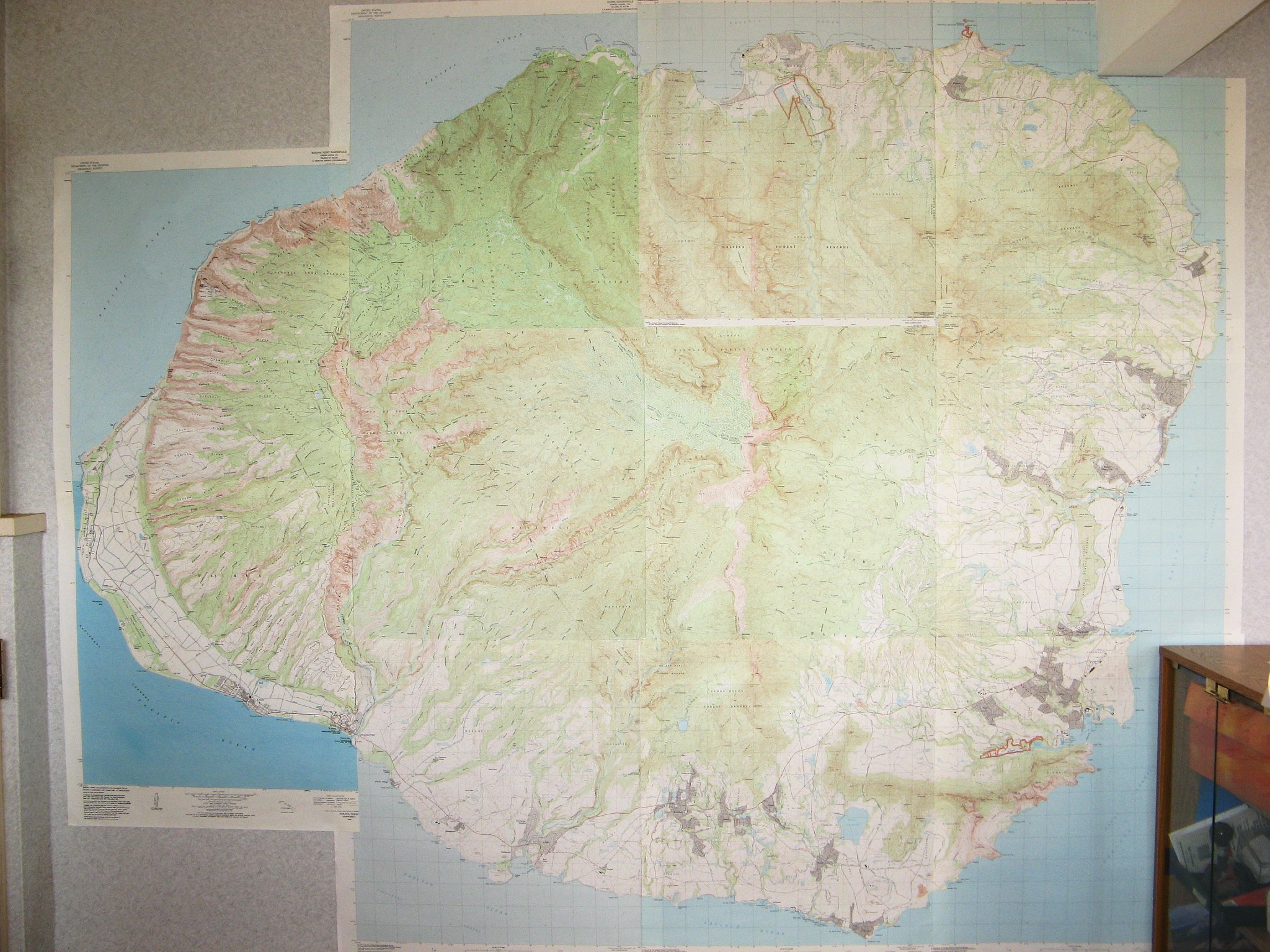
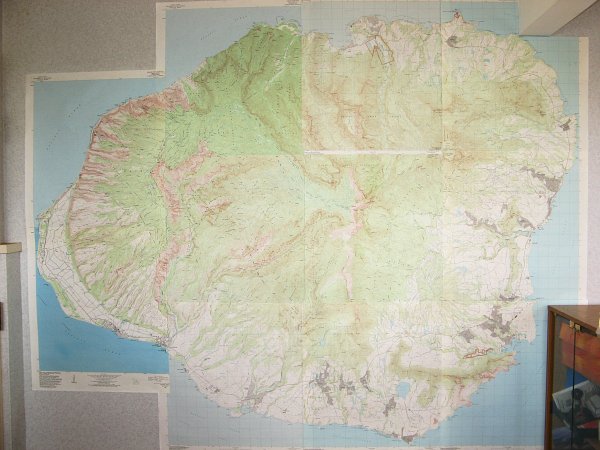
Ever since I first saw these paper maps of Kauai, I’ve wanted to assemble them on my wall to make a mural. Somehow, I just find it fascinating that you can represent a whole island in the highest detail and it still fits on a wall. The island is huge if you’re just a hiker who likes to explore, but not so huge that it can’t be represented on a human scale. My wife bought me the maps several years ago, but putting them together proved to be a challenge, so I didn’t get it finished until early this year. Fortunately, I have a home office, so the rest of my family doesn’t have to live with my idea of interior decoration:


Notice how the outline of Kauai and some features make it look like the head of a warrior keeping an eye directly on Oahu. It’s also looking straight at me and my desk off to the right.

The challenge in putting the maps together is that the quadrangles do not line up perfectly. Some of the maps in print have been updated more recently than others, so they differ slightly in their coverage. Unfortunately, the center map covering Wai’ale’ale and the two above it and upper-left do not line up with the 6 others around them, so some can line up but not all. You can see the white gap in the photo above.

The finished size is roughly 73 by 89 inches (185 by 226 cm)—within an inch depending on how you handle the overlapping. So the second challenge is having the floor space to work on the maps and the wall space to hang them. The large map is quite heavy and wouldn’t stay up with tape, so I ended up gluing wooden slats to the back and hanging those from strings to a hook in the wall.

There are several ways to get these maps. For the printed paper maps, you can buy them at any number of retailers online— just make sure they have all 11 of the Kauai quadrangles in stock. On Kauai, you can buy them at the Kauai Museum shop in Lihue and the Kokee Natural History Museum, all the way up in Kokee. As far as I know, both places stock all 11 maps so you can make the mural. Wherever you get them, make sure you get the most recent printing you can find of each map.

Digitally, you can download the files for free from the University of Hawaii’s coastal imagery website. You can download the whole island as one map, or click on a quadrangle before selecting the format to get each separately—the geoTIFF format is higher resolution than the JPEG format, but you have to extract it from the ZIP file download. I assume that all of these map files were made from updated sources, so they don’t have the overlap problem of the paper maps. The rest of that website has tons of fascinating maps and imagery for all the islands, with a focus on scientific data about the coastal areas—if you’re like me, you can spend hours surfing there.

You can also purchase the National Geographic Topo! software for Hawaii that contains the same seamless map of all the islands, along with the tools to make your own tracks on the maps or download them from almost any GPS. This is fun software, I have the version for California and used to map all my hiking and biking trips. I never bought it for Hawaii because I got my GPS when I moved here, and it had its own mapping software—even though the maps aren’t as nice as the Topo! product. There seem to be two versions of this product, the original one (Windows only) that is cheaper now but with less functionality, or the newer one (Windows and Mac) with 3-D capabilities like Google Earth (both are now in my “bookstore“). I have yet to confirm this, but if you already own a newer version for another state, or the separate upgrade, you can probably get by with the cheaper one because they are the same maps.

One last note about the map mural: I’m sure other people have made this map, but I only know of two other instances. There is one in the volunteer’s bunkhouse at the Koke’e CCC camp, and the other is more accessible in the common room of the Kapaa International Hostel. If you have made one too and found out how to get around the overlap and gap problem, please let me know in the comments.