Highway 1

This doesn’t have much to do with Kauai, but someone asked about California Highway 1 and I had written this for a friend a while ago. In a way, the California coast is similar to Kauai because you have a long stretch of road wedged between the hills and coastline, with lots of towns, side roads, trails, and beaches to explore. The major difference is that it’s warm enough on Kauai for swimming at the beaches.

I used to live in San Jose and explore the coast a lot. I highly recommend the drive, but some sections are better than others. Depending on where you start and how much you want to do, here are my recommendations:

  • If you start in the city of San Francisco, go through the Golden Gate park to Ocean Beach and head south to eventually join up with Hwy 1 near Pacifica. Devil’s Slide is after Pacifica, and it’s really not a big deal when the road is open.
  • Unless you want to see the elephant seals at Ano Nuevo State Reserve, take 92 inland from Half Moon Bay and turn south on Skyline Drive (35). There are places with great views of the Bay and Silicon Valley. Follow signs to Big Basin Redwoods State Park and Santa Cruz. You’ll go through some quirky little communities in the forests. This is slower than the coast, but a much less seen part of the Bay Area.
  • If you’re pressed for time, you can also skip the coast/skyline here and take 280 (“world’s most beautiful freeway”) south to 17 and “over the hill” to Santa Cruz.
  • Santa Cruz and its suburbs to the south are funky “little” coastal communities and a good place to stop for a meal by the wharf, but not really the Hwy 1 experience. South of Santa Cruz isn’t much of an experience either, Hwy 1 is pretty much a freeway to Monterey.
  • Monterey is again a nice town with some history (old plaza and first capital of CA, cannery row), as is Carmel (beautiful mission church), but there’s a lot of tourist fluff. The aquarium is very nice, but it will take at least half a day to get your money’s worth. The 17-mile drive at Pebble Beach is not worth your money unless you’re out of time and won’t see the same beautiful coast for free further south.
  • South of Monterey is where the “classic” Hwy 1 begins. There are no “escape routes,” or rather they are even slower, but this is the most scenic part anyways.
  • A few miles south of Monterey is Point Lobos State Reserve, the best place to explore the coastal rock formations and tidal pools. Ansel Adams and Edward Weston got their inspiration here (I just found other photos here). If you get out of the car just once, I would vote for here.
  • South of Point Lobos is the oft-photographed Bixby Creek Bridge (though that wikipedia photo doesn’t do it justice). There are also many turnouts along the highway to stop for the many views.
  • I don’t know much about Big Sur, other than the bakery (and cafe) along the road used to be very good. The town is crowded in the summer so we never bothered checking it out. There are trail up the canyons to natural hot springs, but they’re crowded too and we never tried to go there.
  • From Big Sur to San Simeon and Hearst Castle, it is a long 65 miles of scenic driving on a rugged coast with few services. If you have the time, there are a few side roads to explore or trails if you want to get out of the car and get a different view of the area:
    • At Julia Pfeiffer-Burns State Park (not the Pfeiffer State Park in Big Sur), walk on a trail under the highway to see a pretty waterfall splashing directly onto the beach.
    • The Nacimiento-Fergusson road winds its way up into the hills for some nice views. It does connect to 101 inland, but it is much smaller and more deserted than Hwy 1.
    • 4 miles beyond the Nacimiento-Fergusson road is Prewitt Creek and a little hamlet called Gorda. There is a trail that starts at the tiny ranger station and climbs up the grassy hillside for some views. Turn around when the trail heads back into the valley.
    • Salmon Creek is 13 miles further and has a short hike up the valley to some waterfalls among huge boulders and Bay trees (a fragrant relative of the bay leaf spice).
  • Hearst Castle is a must if you have a half-day to spare, it’s another tycoon-plunders-Europe-to-build-an-American-chateau, but it’s pretty and the Hollywood stories are interesting. It is popular and you probably need to reserve your tour ahead of time.
  • Cambria is the little artist’s town to the south of Hearst Castle. It has a nice mainstreet with lots of tourist shops. I wasn’t that impressed because like many places, it’s hard to find the character of a place in the 2 hours you spend on Main street.
  • Morro Bay a bit further south seemed more authentic, and it has a nice big rock in the middle of the bay. From there it’s a short drive inland to San Luis Obispo.

For lodging, there’s nowhere to stay between Big Sur and Cambria, except for a few state campgrounds and a tiny lodge in Lucia with a small roadside restaurant. And since Big Sur and Cambria are small, they are expensive and easily full in the summer. Even in bigger towns like Santa Cruz, Monterey and Morro Bay you would probably need reservations during the summer.

Ruffled Feathers

It seems like my letter in the newspaper provoked some response from the helicopter industry. Today’s newspaper has two letters on the subject, one from Safari Helicopters justifying their lawsuit against the safety measures, and another from a pilot who says I don’t know what I’m talking about and calls me names. I will refrain from commenting here until the discussion in the newspaper dies out.

Also, I updated my previous post on this subject with a link to my copy of Jack Harter’s old website.

Wailapa Dam Break Photos 2

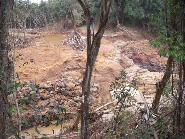
Floods are thought of as acts of nature and many of the people affected by this tragedy want it to be known that its origin is man made, so it is now being called a “dam break” or “dam breach.” However you look at it, the effects are impressive. Wailapa Road just east of the stream is reopened, and I was finally able to go back in the area for some more photos. This is the Wailapa stream bed further downstream of my previous photos, next to the dirt road to Rock Quarry Beach (Kahili Beach). Here, the stream leaves the flat agricultural (now residential) land and cascades down 200 feet (60 meters) to Kilauea Stream near sea level.

Wailapa stream seen from the road to Rock Quarry beach

The picture above is the stream seen from the road. It arrives from the upper-left through a wide area that I believe is a man-made pond, curves around out of sight to the lower left, and then crosses right to some falls in the next pictures. During the flood, much water went straight over at the top of the picture, washing away a driveway that used to be behind the trunk in the center. You can see branches piled up in front a tree that withstood the flow and some building material washed up in the trees in the foreground.

There were some homemade signs and some printed Dam Mad signs posted in this area asking for an independant investigation of the disaster.

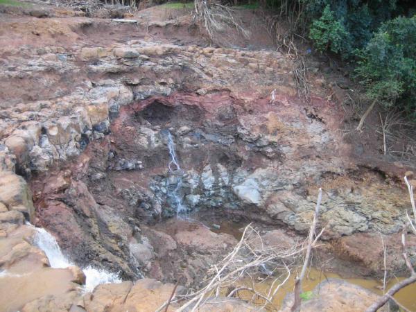
Water seeping from the rock exposed by the flood--can you spot the person in the red rock stratum
Source: Matt Reifslager via Julian Miller

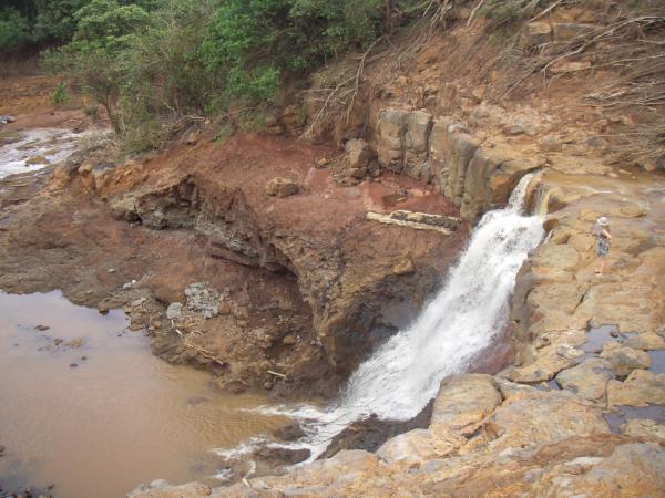
These photos show the waterfall, from the road-side above, and after crossing where the driveway used to be below. I never knew this waterfall was here, or even the stream for that matter. It was a small stream before the dam broke, and the vegetation hid the terrain. A friend refers to it as Bette Midler’s falls, so maybe she owns the property around here. In additions to all the erosion, there is a lot of re-bar in the middle of the falls and you can see a cement and stone wall below. I wonder if there was some sort of construction here that was totally destroyed. I’d be interested in seeing photos of this area before.

Bette Midler falls without any vegetation

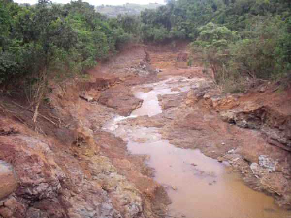
Wailapa streambed eroded down to the bedrock

These photos show the extent of the erosion all down the stream bed. Above is looking down from the falls. Below is from another place on the bluff looking at where Wailapa stream meets Kilauea stream. It’s hard to get a sense of scale on this last one, the current stream is the brown flow at the right of the alluvial deposits, and those are tree trunks on the opposite bank.

View of Kilauea stream from Wailapa Road to Crater Hill

There are more photos of the devastation on The Garden Island website: page 1, page 2. They have some pictures of the reservoirs from helicopters, which I will probably never get to fly in.

Letter to the Editor

My first letter to the editor, entitled “Helicopter industry is not God’s gift to Kaua’i,” was published in today’s Garden Island newspaper, here is the link. The letters published in the Garden Island are very popular on the island, my wife says they are the best part of the paper. There are ongoing discussions about national and local issues, as well as some good government watchdogs and suggestions for improving life on Kaua’i (many centered around stopping development).

Ever since I’ve been hiking on Kaua’i, I’ve wanted to confront the helicopter industry about it’s unsafe practices and warn the public, especially tourists, about the danger. Not being a confrontational person, nor really having the time to launch a campaign, I never did more than report on accidents here. The local Sierra Club has an old web page about responsible helicopter tourism, but when I contacted them, they said they were no longer active on the topic.

The debate began last week when one of the operators defended the helicopter industry in a letter to the editor, and I felt their spin could not go unopposed. Their false excuses show they are more committed to booking customers than to safety or customer experience. It all started when someone else wrote about their unsafe flying in Waimea Canyon during the recent rainy weather with low clouds.

Writing my letter took a bit of research because although a lot of information is on the internet, it’s hard to interpret the legal documents. I ended up talking to an FAA investigator on Oahu who gave me all the details about the altitude limits in practice and in plain language. When I asked him if people should be reporting low-flying helicoters to his office, he said it would be a good thing to have more incident reports. He said it is best if you can photograph or film the incident and record the tail number of the aircraft. You should also note the time, date, and accurate location (look on topozone.com or email me and I can help). The phone number for the FAA flight standards office on Oahu is 808-837-8300 (press 0 to speak to the operator and ask to file a report).

PS: Someone has already told me that it’s not “undefendable” but “indefensible,” I can’t believe I didn’t catch that.

Update 4/12/2006: I forgot to include the link to the old Jack Harter website that I mention in the letter to the editor. When I saw it, I saved a copy of the files, and indeed it changed soon thereafter to its present form (oddly, it looks like he didn’t get jackharter.com).

Scott Hawaii

I have endorsed flip-flops by Scott before, and just bought myself another pair because the outer sole was wearing thin after a year of constant use. From the tag on the new pair, I was happy to find that it is a Hawaiian brand. It always feels good to buy from local businesses, even if the manufacturing is inevitably off-shore:

Scott Hawaii was founded in 1932, manufacturing plantation boots for the sugar and pineapple workers in Hawaii. During World War II, because of material shortages, production was switched to sandals and flip flops to service the large number of military personnel passing through Pearl Harbor. Since then, we have focused on providing comfortable footwear in Hawaii for locals and tourists alike, as well as those outside Hawaii who embrace our casual island lifestyle. Every pair we make is hand crafted with the best quality and most durable materials available for comfortable, casual footwear.

[on the back:] Made in China

They also have a small website, www.scotthawaii.com, which is worth visiting for the retro flash animation and nice Hawaiian slack key guitar music. The model that I have found at Kmart on Kauai is their men’s Makaha, though only in plain black.

Please note that I am in no way affiliated with Scott Hawaii, I’m just a satisfied customer recommending what seems to be a quality product.