Happy Thanksgiving

I’m a bit late with the post, but at least it’s still the Thanksgiving weekend.

While Thanksgiving might be associated with cold weather and leaf raking in North America, I have no qualms about celebrating Thanksgiving in Hawaii, as I do Halloween. Thanksgiving was brought to Hawaii by the missionaries, probably more as a cultural memory of home than as a religious celebration. However, it was originally a harvest festival, and Hawaiians historically celebrated the Makahiki festival starting around this time. Although food plants grow year-round in Hawaii, the winter rains and shorter days weren’t ideal for the taro Hawaiian taro farming and the last major harvest was in November. Makahiki was a 4-month season of peace, feasting, games, and praying for the next year’s crops.

While Thanksgiving has become a football and shopping blitz here as well, I like to think of the good side of Thanksgiving, where pilgrims created a new holiday for the New World, outside of the religious calendar but religious in their own persaonl way, where families get together, and where each and every one looks inside themselves to ponder what they should be grateful for. One seasonal event we can be thankful for here in Hawaii is the end of the hurricane season (June 1-November 30). And a feast is a good way to start eating all the canned food we’ve been stockpiling:

Double cupboard full of canned vegetables, fruit, soy milk cartons, and cereal boxes

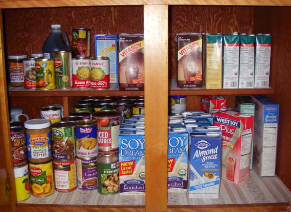
Actually, that is only half of what we have, nor does it show the 12 gallons (45 liters) of drinking water in jugs. We start buying lots of cans and soy milk as they go on sale all spring and summer, and we’ll eat them all winter and spring so we can get new ones next year. Not having lived through a hurricane and its aftermath, I have no idea if this is the right amount of food. We can at least avoid the stress of shortages when a hurricane gets near, and I think we could live 2 weeks with what we have.

Deadly Bike Route

At the end of October, a man on a bike was killed in a hit-and-run accident on Kuhio highway, across from the Wailua golf course. In the newspaper article about it, they say they found a mangled bicycle propped up against the guardrail and the man’s body in the ditch on the other side. Another article says the police have apparently identified a suspect but haven’t made any arrest yet (it also mentions a different location, but I think it is the same incident).

Like in much of America, bicycles are an afterthought on Kaua’i. If the shoulder is wide enough, it is designated as a bike route. When the shoulder gets narrower, such as on Kaumualii highway before the road to Poipu, there is a sign saying “End Bike Route” in the middle of nowhere. In the case of this fatality, he was on a bike route, but in a location really too narrow to be designated as such. Here is the area and the sign:

The southbound shoulder of Kuhio highway squeezed between a pickup truck whizzing by and an unbroken guardrail, yet proclaimed Bike Route by the sign

In this photo near where the man was reportedly killed, you can see the ditch on the right side, and the guardrail between the roadway and the ditch. The shoulder itself is only about two feet wide, and the pickup truck in the photo is near the double yellow line, giving the photographer or biker another two feet of space. Needless to say, not all drivers are as courteous, and large trucks can’t be.

To give credit to the road maintenance crews, the weeds used to grow from under the guardrail and onto the shoulder, making it ever more narrow and dangerous. But even before this incident they either cut them or sprayed herbicide to get rid of them. I actually first considered taking this picture when there were vines growing out of the top of the sign (if you look carefully, you can see where they were cut).

I’m creating the new category Transit to deal with bicycles, cars, buses, roads and bridges on Kauai.

Lonomea Lessons

This is the continuation of the Lonomea Adventure.

With half of everyone’s gear stashed on the other side of the Waimea River, I volunteered to go back and fetch it as soon as the river allowed. I hesitated going the next day because I had no guarantees that the river would be lower, and I didn’t want to hike down and up the Kukui trail just to find out it wasn’t.

Fortunately, the National Weather Service has some very useful information on the internet, including real-time stream gauges and 3-hourly rain gauges. The cumulated rain records revealed that it indeed did rain heavily at Waialeale and most likely in the Alaka’i swamp while we were hiking under a blue sky. The following map shows that the National Weather Service recorded 3.84 inches (9.8 cm) from 8am to 8pm on the day of the hike:

Outline map of Kauai from the NOAA and NWS showing the cumulated 12-hr rainfall for each rain gauge on Kauai
Source: National Weather Service
Honolulu Forecast Office

Even more dramatic is how the stream flow responded to this downpour. The following graph shows the flow of Waialae stream, the next side canyon south of Koaie and very similary in topography. The flow is graphed logrithmically, but since flow is related to the square of the streambed cross-section, I am assuming the logrithmic scale creates a curve that represents actual water depth:

Graph of stream flow, rising sharply ten-fold around noon, staying high until midnight, and only dropping down half again by noon the next day.
Image credit: U.S. Geological Survey

That graph also shows two other interesting facts. The earlier rains must not have drenched the highlands nor the canyon nearly as much because the stream barely rose in the previous peak. It also confirmed to me that the water was going down and I’d have a good chance of crossing the river, given that it hadn’t started raining again. So I went back the following afternoon and hiked down the Kukui trail, wondering how accurate all these data really were. Fortunately, when I made it to the crossing, it was about halfway down from the high water we saw the day before, enough to get across without getting wet:

The same crossing with water just flowing over the tops of the rocks, and a view of my green and yellow frog-toed tabis

I was able to cross in tabis by stepping on the rocks and not ever getting wet above my knees. Tabis are Japanese water mocassins with non-slip felt soles that I’m wearing in the picture above. I found our hidden bags, crossed again, and hiked out by dusk.

Lessons that I learned from this experience:

  • Don’t cross the Waimea river if you know there is rain on the East side of the island. It is most likely raining in the swamp as well, and the streams will rise. There is a great hike up the bottom of the canyon to a water diversion dam that does not require crossing the Waimea River.
  • Check the rainfall and stream height before going. Here are the useful links:
  • On days when you are not sure of the rain forecast but want go anyways, carry some extra food, an extra shirt or jacket, a water pump, and a lighter. There is a hunter’s camp with sheltered picnic table, fire ring and compost toilet on the other side of the river, right near the crossing.
  • Always carry a flashlight on every hike, no matter when you go or plan to get back. I really recommend the Petzl Tikka headlamp because it is small and light.
  • Don’t buy tickets for a concert the night of a full-day hike. Even if you get back in time, you might not feel like going.

Lonomea Adventure

Back in October, I led a Sierra Club hike to Lonomea, in the Waimea Canyon, and we had quite an unplanned adventure to get home. Lonomea is a hunter’s camp at the end of the maintained trail up Koaie Canyon, which is one of the side canyons of the Waimea River. To get there, we hiked down the Kukui Trail, crossed the Waimea River further upstream, and hiked up the Koaie Canyon trail, for a total of about 6 miles one way.

Shaded topographical map of Waimea and Koaie Canyons showing the trails we took--created by the author with ArcExplorer GIS

It had been raining off and on that week, and while there was rain predicted in Lihue the day of the hike, there was only a chance of showers on the West side. Knowing that it is drier in the Canyon, I did not want to cancel the hike. Sure enough, after some mist and a rainbow at the beginning of the hike, we had sunny blue sky the rest of the day. Crossing the river was easy, some people even made it hopping across with their shoes on. I was actually surprised the river was so low, give it had rained earlier in the week.

Fording the Waime River in shallow water and on exposed rocks
Photo credit: Scott Pierce

As we hiked up Koaie Canyon, I thought I could hear the stream quite loudly, much louder than usual. However, there aren’t any places until Lonomea Camp where the trail gets close enough to the stream to get a good look. We were all hot from hiking and looking forward to the swimming hole there, but we got a surprise instead. The river was obviously running very high with muddy water, far too dangerous for swimming. In this next picture, you’ll notice that the sky is still blue, even looking inland toward the Alaka’i Swamp where the stream originates:

Whirlpool of brown foamy water and submerged rocks at the Lonomea swimming hole

At this point, I knew we would have trouble getting back across the Waimea River, but given it was so low before, I thought it would still be crossable. This was wishful thinking because the river was about 2 feet higher when we got back to the crossing. I waded out into the current to see how strong it was, but I could barely keep my balace once the water went above my hips. It would not have been so deep if I could stand on the rocks again, but they were impossible to find in the muddy water:

Yours Truly up to his stomach in churning water and barely 15ft/5m from the near shore and the far shore looking very far indeed
Photo credit: Scott Pierce

We marked the high water line with a stick and searched for another way across. Where there were larger rocks, there were also rapids that were much more dangerous, and nowhere was the river wide and shallow enough. After about an hour, the water hadn’t even started to go down and we were wondering if we would have to spend the night. Looking again, we found a place right near the confluence of the Koaie Stream where we could swim across. This place was actually deeper so there were less rocks and it was far upstream from the nearest rapids.

We made a plan for the strongest swimmers to go across first and signal to the rest how they felt about it. Then, if the weaker swimmers still preferred to camp overnight and wait for the river to go down, at least somebody could hike out and notify our families. As it turned out, the strong swimmers signalled that it wasn’t difficult, and one by one, we all made it across, with the first ones reaching out to help catch the next ones.

We left half our gear before crossing, and some of us had to hike up the 2,200 feet to the rim in our water shoes. We sent the strong hikers ahead to call our worried families, and the rest of the group made it back to the cars by 8pm, with the help of 2 flashlights. Everyone was still a bit wet, some people got a bit cold hiking out, others did not make it to their concert that night, but everyone got home safely. We even felt that the teamwork needed to get across the river had been an empowering experience.

Geckos & Other Guests

Our friend Gabriela Taylor just published her first book about Kaua’i, subtitled Tales of a Kaua’i Bed & Breakfast. After 30-some years on Kaua’i, she says she’s finally starting to feel and be treated like a local. And she has lots of great stories going all the way back to the Hippie camps in the 70’s (although Taylor camp was not named after her).

From the book’s website (designed by my wife Sonja) where you can also read excerpts and buy the book:

“Life at a B&B is often so alluring that many guests fantasize about retiring in paradise and running one of their own. Author Gabriela Taylor does not entirely dispel this image, for she built and ran a B&B for twelve years on the island of Kaua‘i.”

Cover of Gabriela Taylor

You can also buy the book at the Borders in Kukui Grove, where Gabriela will soon have a talk-story and sign books.

I’ll file this under History because I don’t think I’ll have enough Literary entries to justify starting a new category.