Kalalau Updates

I received a good question in the comments from Mike:

I have hiked all or portions of the Kalalau Trail many times over the past 35 years but only in the summer. I will be on Kauai this November for Thanksgiving and want to hike Ke’e to Hanakoa. Given the date of Nov 29th what would I reasonably expect for weather and hours of daylight? I figure about +/- 4 hours each way maybe less. Mahalo

You’re lucky, Mike, because there are two big changes in Kalalau permits right now, but you should not be affected.

The first is that the entire Kalalau trail beyond Hanakapi’ai and all the campsites are being closed for two months starting last week. I have to assume it started, because I’m not on-island right now, and I’m just reading about it on the State Parks website and Garden Island newspaper. This unprecedented closure is for “rockfall mitigation” on the cliff that overhangs the waterfall, beach and first cave area.

They say the work should easily be done by the beginning of November, so you have several weeks of buffer in case the work runs over. Still, you should call and get a permit for your stay (I am assuming they’re issuing permits for the end of November, I haven’t confirmed it myself). Because if they don’t finish the work, the trail will be closed, and they will probably notify permit holders.

The second is that there has been a slight change to the camping permits for Hanakoa. From the State Parks website again:

[B]eginning May 19, 2010, permits for Napali Coast will be issued for Kalalau only, the preferred destination at the end of the 11-mile Kalalau Trail. However, permits for Kalalau will also be valid for camping at Hanakoa, which is located a little beyond the halfway point of the trail, roughly 6 miles in from the trailhead. Permits specifically for Hanakoa will no longer be issued, but hikers are encouraged to stopover and camp at Hanakoa if they possess a valid permit for Kalalau and they feel the need to break up their trek due to such factors as fatigue, inclement weather, or impending darkness.

This new policy will also take the mystery out of the trip planning process for visitors who are unsure whether they can make the full trail in one clip. This provides the flexibility to stop at Hanakoa or continue on to Kalalau without apprehension regarding the legality of a permit.

So you’ll need to ask for a Kalalau camping permit, even if you know you’re only going to Hanakoa. It won’t hurt to tell them where you plan to stop, but I assume it also simplifies their permit system to only record Kalalau permits. I doubt they changed the quotas in Kalalau to account for this new policy, but I don’t think you’ll have any trouble in November.

However, one reason for easy permit availability is that the first winter storm, the kind that covers the whole island for 2-4 days, usually happens between mid-November and mid-December. Be sure to check the weather forecasts, because storms usually mean flash flooding, and you don’t want to get in a dangerous spot or be trapped for an extra day because you can’t cross back over Hanakapi’ai stream.

Assuming you avoid the storm, the rest of the time can be hit or miss with overcast skies and rain or nice sunshine. And the section between Ke’e beach and Hanakoa is the wettest in general, so expect slippery rocks and mud on the trail. I strongly suggest sturdy hiking boots and a pair of hiking poles. The upside is that you’re going for just one night, so it’s easier to put up with being wet, because you know you’ll be hiking out the next day.

As for hours of daylight, I found a simple website that gives sunrise and sunset times for Honolulu, which should only be a few minutes off from Kaua’i (some hiking GPS devices can give you this info too). For November 29, it says sunrise at 6:51am and sunset at 5:48pm, so you get 11 hours of daylight. In the tropics, winter days aren’t as short as on the mainland (but summer days aren’t as long).

I would count on at least 4 hours each way, and only if you’re going light and not planning many stops. Personally, I like the valleys between Hanakapi’ai and Hanakoa, so I like to take my time there if I can. You’ll still have plenty of time to hike to the waterfall at Hanakoa, it’s less than a half mile from the campsites there. In any case, have a great hike and let us know in the comments how it went.

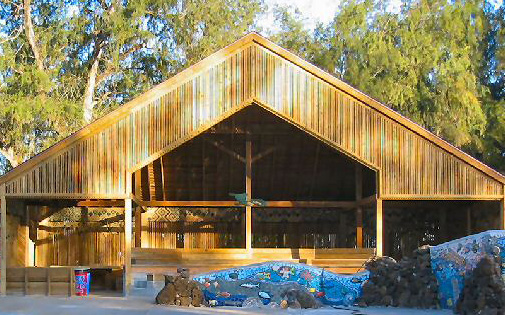
The Kamalani Pavilion

A friend on the mainland is planning her family’s visit to Kaua’i and told me how sad she was that the Kamalani Pavilion and its artwork had burned down. Since this will be her first visit, I’m not sure where she heard about the pavilion, maybe a recent update of a visitor’s guide mentions it.

The Kamalani Pavilion at the southern end of Lydgate park was meant to be a gathering place for groups of campers, such as Boy Scouts, but the campground at Lydgate has never opened. It was built by the Friends of Kamalani in the spring of 2004, using wood leftover from the nearby play-bridge. Sometimes called the art pavillion, it contained wood carvings made by children and by accomplished artists. Fortunately, the ceramic art embedded in the cement benches and outdoor fireplace did survive.

KamalaniPavilion1
Source: kamalani.org

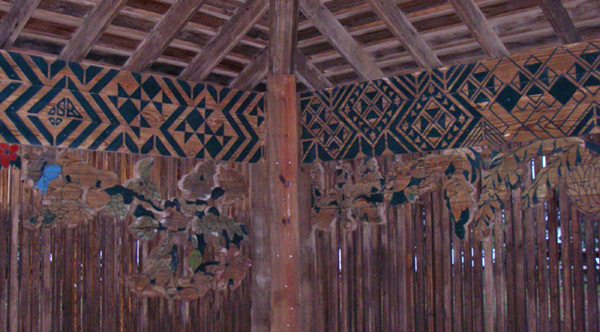
In any case, I remembered that I had taken a few photos of the beautiful artwork in the pavilion before it was destroyed, so I offer them here for posterity. There were two friezes all around the inside of the building. The top one had a tapa cloth motif, and one below it, a floral and vegetation motif, tropical of course.

KamalaniPavilion2

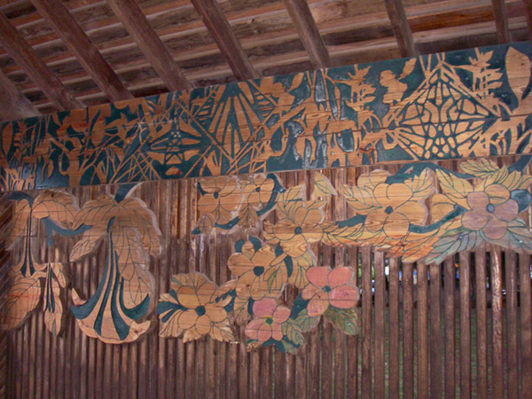
I was really intrigued by this one section, which doesn’t appear to be a tapa pattern anymore. I’m not sure what it is, but I like the negative outlines and mix of geometric and what looks like leaf patterns.

KamalaniPavilion3

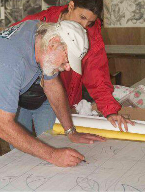
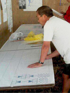
The Friends of Kamalani website has lots of pictures of the construction and wood carving. They even show the artists working on paper layouts of the friezes, but it doesn’t give their names:

KamalaniPavilionArtist1
Source: kamalani.org
KamalaniPavilionArtist2
Source: kamalani.org

That website has more photos of the construction and links to many more, but I didn’t see any that show the finished works in their entirety. I do hope it’s documented somewhere—if you know more information, leave a comment.

And there was talk of starting to rebuild the pavilion ever since the fire, but I haven’t heard what the status is recently.

The Strange Case of Queen’s Bath

Queen’s Bath in Princeville is notorious for its change of moods. It’s one of those controversial places outed by the Kaua’i Revealed guidebook as an undiscovered gem: a turquoise and emerald pool set in black lava with views of Bali Hai. Except it’s also a lava bench on the North Shore of Kaua’i exposed to the deadly winter surf–which is why I’m comparing it to the Strange Case of Dr Jekyll and Mr Hyde.

Along with the increase in popularity, there has been an increase in accidents and drownings. Most of the incidents occur in the winter, when high waves sweep over the rocks, and unaware people get knocked into the churning waters. Google’s satellite view of Queen’s Bath was taken in the winter when the wash of the waves covers the pool. It should be about in the center of this view:


Source: maps.google.com

This impressive video shows high winter surf (12-15 feet) at Queen’s Bath itself. It goes to the start of the high surf when you click play:

After every incident or death, people talk about closing the access, essentially to protect visitors who are not familiar with ocean conditions. In fact, it was closed for a while in 2002 because of, you guessed it, a lawsuit against the county. It quickly reopened with disclaimer signs to remove any county liability—the typical signs that no one heeds.

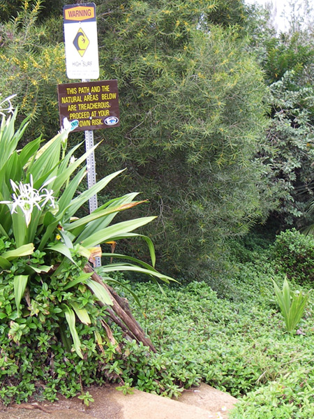
QueensBathOldSigns
Click for large version

For the record, those signs read: “Warning – High Surf” and “This path and the natural areas below are treacherous. Proceed at your own risk.”

Then in 2007, somebody got a video of a kid getting swept off a ledge. Two things about this video: he was down on the ledge near the water on purpose to play in the water, and this is the cove before you get to Queen’s Bath, not the pool itself. Even on low surf days, the shape of this inlet amplifies the rise and fall of the wave.

More recently, there have been new signs tallying the deaths, in an attempt to really get people’s attention. This is reminiscent of the sign at the entrance to the equally dangerous Hanakapi’ai beach. These signs were put up by a concerned individual (the same guy who placed life buoys at ungarded beaches), but paradoxically, the county is against them, probably because they weren’t written by a lawyer (the county is allergic to anything that might give them liability).

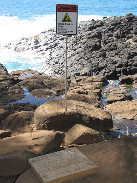
QueensBathNewSigns
Click for large version

These say: “Warning – Waves break on ledge. Stand back.” and “Queen’s Bath drownings: 28 [with skull and cross-bones]. Unexpected large waves will knock you off rocks & out to sea.”

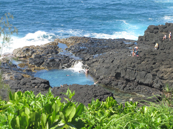
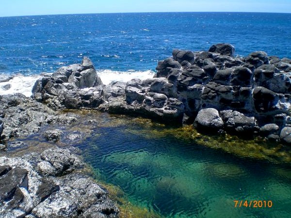
Despite the scare tactics, conventional wisdom is that Queen’s bath is safe in the summer. The surf is lower and barely washes over the rocks to refill the pool, and there are people walking on the rocks and swimming in the pool. I’ve experienced such conditions as early as April and swam there with my daughter. As seen in this overview, the actual Queen’s Bath pool is set back from the waves, and it drains in a channel that does not go directly back into the ocean, but curves around out the bottom of this photo:

QueensBathOverview

But just recently, I received some photos from a visitor who described the following situation last week (early July). Here are the conditions that this visitor encountered just before—typical summer low surf, with the sea level far below the dry rocks (Dr. Jekyll):

QueensBathDrJekyll
Source: Used by permission.
:

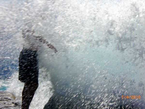
We also went to Queens Bath, found a great little pool to play in. My brother- in-law was standing on the rocks looking out over the ocean, when, a big wave came and knocked him down and almost into the raging ocean below. … And somehow, running from that wave, I got a picture of the wave picking him up.

Mr Hyde strikes:

QueensBathMrHyde
Source: Used by permission.

He was so very lucky!! Just a cut on his hand and a sore booty! We saw all the warning signs, so we were very careful. That wave just came from nowhere. Please everyone be very careful!

Moral of the story: I won’t be one of those people who tells you not to go, so be informed, get the surf report, don’t go onto the rocks if there are waves, and even if there aren’t big swells, don’t go close to the edge. I would add “don’t turn your back on the ocean and watch the swells,” but that’s exactly what this guy was doing, and he still got knocked down and injured.

Public Access Waterways

Jenine just asked an interesting question in a comment to my post about kayaking the Hanapepe River:

If you keep going up this river, does it lead you to Manawaiopuna falls? or Jurassic falls? Is the river county of kauai property? or does it become private property?

Manawaiopuna is the “Jurassic” falls, seen in the movie Jurassic Park, and yes it is a tributary of the Hanapepe River, although the upper segment of Hanapepe river is called Koula river. I found some great shots of this beautiful waterfall that I published in a previous post about helicopter landings.

This question is obviously trying to understand whether it is possible to visit these falls by following the river, given that all the surrounding land is private. And from my understanding, the answer is no.

Navigable rivers are State property, I believe, and open to the public from the ocean up to the point of highest navigation. Beyond that, I imagine they are part of the adjoining property. I am not a lawyer, and I don’t know how the laws define “navigable,” but I’ve taken that to mean anywhere you can paddle a kayak.

But Kaua’i rivers are all very short, and inland of the coastal plain, they are really just mountain streams with rocky bottoms. So you usually cannot paddle more than a mile or two inland before being blocked by rapids or shallow rocks. And unlike beaches that are public up to the highest reach of winter storm waves, there is no shoreline access along rivers. So as soon as you set foot on land next to a river, or in a non-navigable part of the river, you’re on someone’s property:

  • State Park: we’re fortunate to have the Wailua River state park to protect the land around the Wailua River. This lets tie up your kayak and explore the shore at the Fern Grotto and Secret Falls. But there are no other state parks along navigable rivers.
  • Wildlife Refuge: the National wildlife refuges along the Kilauea and Hule’ia Rivers are federal government property (the only federal parks on Kaua’i), but for the sake of the ecosystems they seek to protect, they are strictly off limits.
  • Private property: on the coastal plains, the land beside the rivers is often prime agricultural land, either fields or pastures. And understandably, the farmers don’t want anyone around their fields.

The upper valley of the Hanapepe river, from just beyond the small farms, is entirely owned by the Robinson family. They bought it almost 150 years ago to grow sugar cane and provide irrigation water. And I know they have some irrigation ditches, private access roads, and caretaker housing near the river further upstream from Hanapepe. So not only would you be tresspassing if you tried hiking up the Hanapepe River, you’d likely be found quickly by the workers there.

As with any private property, you can receive permission from the landowner to pass. But in the case of the Robinson property, I wouln’t know where to ask, and knowing how protective they are of their land, I doubt they would grant it.

In any case, even if there were public access, Manawaiopuna waterfall is far into the interior. It’s about 8 miles up the river from where you have to stop paddling, or about twice as far as you can see up the valley from the Hanapepe roadside lookout. Here is the Manawaiopuna waterfall in Google Maps; zoom out to see how remote this is:


maps.google.com

Hands Across the Sand

Today, at beaches all over the US and in places around the world, people joined hands to protest the BP Gulf disaster. By extension, people were also showing their support for using less oil and more renewable energy, hopefully reversing America’s oil addiction. This demonstration was organized and publicized by Hands Across the Sand, an organization that has been opposing offshore oil drilling since before the disaster.

The joining of hands was scheduled for noon, local time, and some people have posted videos and photos already. Here is one from the Hands Across the Sand at the Hanalei Pier:

There was another event planned at Lydgate by the Surfrider foundation, so maybe it had an even bigger turnout. I haven’t found any photos or videos online yet.

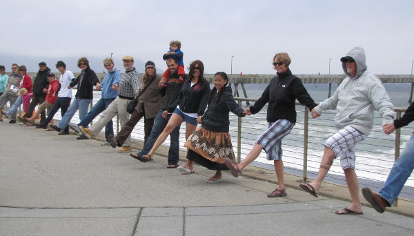
Me? I was near a pier, but in Pacifica, California. Sadly, we had a rather low turnout:

HandsAcrossTheSandPacificaCA1

But we had a great slogan and dance routine: “Kick the oil habit!”

HandsAcrossTheSandPacificaCA2

I like to think everyone was at Ocean Beach in San Francisco: